 Warner Robins
Wantagh
Bethel
Misty Hill Farm
United States
Wakonda Beach (R33) Airport
Wilmington
Poland
Miami International Airport
Warner Robins
Wantagh
Bethel
Misty Hill Farm
United States
Wakonda Beach (R33) Airport
Wilmington
Poland
Miami International Airport
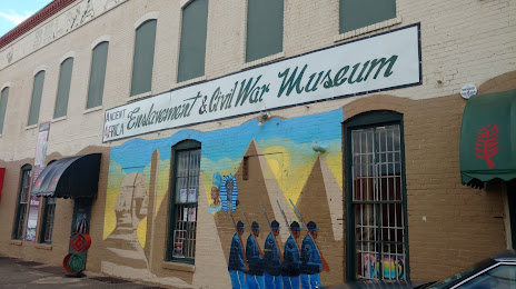
Slavery & Civil War Museum on the map, Selma, United States
Photo
Where is located Slavery & Civil War Museum
Slavery & Civil War Museum — local attraction, which is located at 1410 Water Ave, Selma, AL 36703, United States and belongs to the category — museum. Average visitor rating for this place — 4.1 (according to 58 ratings, information from open sources and relevant for 2022).
Exact location — Slavery & Civil War Museum, marked on the map with a red marker.
You can get directions to Slavery & Civil War Museum on the map from your location.
What else is interesting in Selma? You can see all the sights if you go to the city page.
Coordinates
Slavery & Civil War Museum, United States coordinates in decimal format: latitude — 32.407659220602, longitude — -87.01556437527789. When converted to degrees, minutes, seconds Slavery & Civil War Museum has the following coordinates: 32°24′27.57 north latitude and -87°0′56.03 east longitude.
Nearby cities
The largest cities that are located nearby:
- Montgomery — 67 km
- Birmingham — 125 km
- Mobile — 213 km
- Huntsville — 260 km
- Atlanta — 284 km
- Jackson — 296 km
- Chattanooga — 330 km
- Tallahassee — 340 km
- New Orleans — 399 km
- Metairie — 402 km
- Memphis — 408 km
- Nashville — 416 km
- Baton Rouge — 448 km
- Clarksville — 457 km
- Knoxville — 481 km
- Lafayette — 535 km
- Little Rock — 544 km
- Gainesville — 544 km
- Savannah — 556 km
Distance to the capital
Distance to the capital (Washington) is about — 1155 km.