 Warner Robins
Wantagh
Bethel
Misty Hill Farm
United States
Wakonda Beach (R33) Airport
Wilmington
Poland
Miami International Airport
Warner Robins
Wantagh
Bethel
Misty Hill Farm
United States
Wakonda Beach (R33) Airport
Wilmington
Poland
Miami International Airport
Spring Creek Park on the map, Tomball, United States
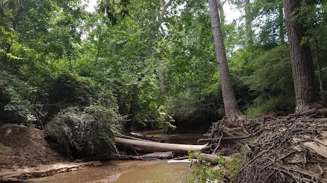
Photo
Where is located Spring Creek Park
Spring Creek Park — local attraction, which is located at 15012 Brown Rd, Tomball, TX 77377, United States and belongs to the category — park. Average visitor rating for this place — 4.7 (according to 1150 ratings, information from open sources and relevant for 2022).
Exact location — Spring Creek Park, marked on the map with a red marker.
You can get directions to Spring Creek Park on the map from your location.
What else is interesting in Tomball? You can see all the sights if you go to the city page.
Coordinates
Spring Creek Park, United States coordinates in decimal format: latitude — 30.102469036875583, longitude — -95.64737167927123. When converted to degrees, minutes, seconds Spring Creek Park has the following coordinates: 30°6′8.89 north latitude and -95°38′50.54 east longitude.
Nearby cities
The largest cities that are located nearby:
- Houston — 44 km
- Beaumont — 143 km
- Austin — 204 km
- Waco — 216 km
- Killeen — 229 km
- San Antonio — 287 km
- Corpus Christi — 308 km
- Mesquite — 309 km
- Dallas — 316 km
- Grand Prairie — 320 km
- Shreveport — 320 km
- Arlington — 323 km
- Irving — 325 km
- Garland — 325 km
- Richardson — 332 km
- Fort Worth — 334 km
- Plano — 338 km
- Carrollton — 339 km
- Lafayette — 344 km
Distance to the capital
Distance to the capital (Washington) is about — 1961 km.