 Warner Robins
Wantagh
Bethel
Misty Hill Farm
United States
Wakonda Beach (R33) Airport
Wilmington
Poland
Miami International Airport
Warner Robins
Wantagh
Bethel
Misty Hill Farm
United States
Wakonda Beach (R33) Airport
Wilmington
Poland
Miami International Airport
Cook's Slough Sanctuary on the map, Uvalde, United States
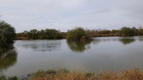
Photo
Where is located Cook's Slough Sanctuary
Cook's Slough Sanctuary — local attraction, which is located at Uvalde, TX 78801, United States and belongs to the category — bird watching area. Average visitor rating for this place — 4.6 (according to 28 ratings, information from open sources and relevant for 2022).
Exact location — Cook's Slough Sanctuary, marked on the map with a red marker.
You can get directions to Cook's Slough Sanctuary on the map from your location.
What else is interesting in Uvalde? You can see all the sights if you go to the city page.
Coordinates
Cook's Slough Sanctuary, United States coordinates in decimal format: latitude — 29.18484263151259, longitude — -99.79099097535538. When converted to degrees, minutes, seconds Cook's Slough Sanctuary has the following coordinates: 29°11′5.43 north latitude and -99°47′27.57 east longitude.
Nearby cities
The largest cities that are located nearby:
- Piedras Negras
 (Mexico) — 91 km
 - Ciudad Acuna (Mexico) — 113 km
- San Antonio — 127 km
- Laredo — 188 km
- Nuevo Laredo (Mexico) — 193 km
- Austin — 227 km
- Corpus Christi — 281 km
- Killeen — 287 km
- Monclova (Mexico) — 301 km
- Abilene — 358 km
- Waco — 359 km
- McAllen — 366 km
- Reynosa (Mexico) — 376 km
- Apodaca (Mexico) — 381 km
- General Escobedo (Mexico) — 383 km
- San Nicolas de los Garza (Mexico) — 386 km
- Monterrey (Mexico) — 393 km
- Guadalupe (Mexico) — 393 km
- Santa Catarina (Mexico) — 397 km
Distance to the capital
Distance to the capital (Washington) is about — 2350 km.