
 Maureville
Samoëns
Gréning
Toulouse
Volx
Goudet
Méhoncourt
Saint-Hymer
Pontcarré
Maureville
Samoëns
Gréning
Toulouse
Volx
Goudet
Méhoncourt
Saint-Hymer
Pontcarré
Lighthouse Cap Levi on the map, Octeville, France
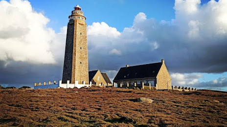
Photo
Where is located Lighthouse Cap Levi
Lighthouse Cap Levi — local attraction, which is located at 9 Le Cap Lévi, 50840 Fermanville, France and belongs to the category — lighthouse. Average visitor rating for this place — 4.6 (according to 389 ratings, information from open sources and relevant for 2022).
Exact location — Lighthouse Cap Levi, marked on the map with a red marker.
You can get directions to Lighthouse Cap Levi on the map from your location.
What else is interesting in Octeville? You can see all the sights if you go to the city page.
Coordinates
Lighthouse Cap Levi, France coordinates in decimal format: latitude — 49.695841149859625, longitude — -1.4732160747463787. When converted to degrees, minutes, seconds Lighthouse Cap Levi has the following coordinates: 49°41′45.03 north latitude and -1°28′23.58 east longitude.
Nearby cities
The largest cities that are located nearby:
- Caen — 105 km
- Bournemouth
 (United Kingdom) — 122 km
 - Le Havre — 127 km
- Portsmouth (United Kingdom) — 138 km
- Southampton (United Kingdom) — 143 km
- Rennes — 167 km
- Exeter (United Kingdom) — 179 km
- Eastbourne (United Kingdom) — 185 km
- Crawley (United Kingdom) — 193 km
- Rouen — 199 km
- Reading (United Kingdom) — 207 km
- Bristol (Great Britain) — 212 km
- Swindon (United Kingdom) — 213 km
- Sutton (United Kingdom) — 217 km
- Slough (United Kingdom) — 221 km
- Le Mans — 226 km
- London (United Kingdom) — 233 km
- Oxford (United Kingdom) — 236 km
- Watford (United Kingdom) — 240 km
Distance to the capital
Distance to the capital (Paris) is about — 293 km.