
 Józefów nad Wisłą
Gorzyce Wielkie
Rogówek
Sromowce Niżne
Wyszków County
Kruszewo
Jantar
Sady Górne
Nagoszewo
Józefów nad Wisłą
Gorzyce Wielkie
Rogówek
Sromowce Niżne
Wyszków County
Kruszewo
Jantar
Sady Górne
Nagoszewo
Rudawy Landscape Park on the map, Kamienna Góra, Poland
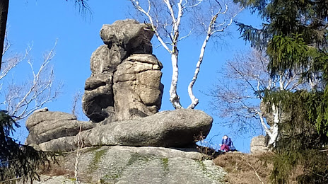
Photo
Where is located Rudawy Landscape Park
Rudawy Landscape Park — local attraction, which is located at 58-400 Kamienna Góra, Poland and belongs to the category — park. Average visitor rating for this place — 4.8 (according to 2594 ratings, information from open sources and relevant for 2022).
Exact location — Rudawy Landscape Park, marked on the map with a red marker.
You can get directions to Rudawy Landscape Park on the map from your location.
What else is interesting in Kamienna Góra? You can see all the sights if you go to the city page.
Coordinates
Rudawy Landscape Park, Poland coordinates in decimal format: latitude — 50.81957147809607, longitude — 15.908115925294208. When converted to degrees, minutes, seconds Rudawy Landscape Park has the following coordinates: 50°49′10.46 north latitude and 15°54′29.22 east longitude.
Nearby cities
The largest cities that are located nearby:
- Walbrzych — 18 km
- Legnica — 48 km
- Wrocław — 79 km
- Zielona Gora — 132 km
- Opole — 134 km
- Prague
 (Czech Republic) — 137 km
 - Cottbus
 (Germany) — 158 km
 - Olomouc (Czech Republic) — 158 km
- Dresden (Germany) — 162 km
- Kalisz — 178 km
- Brno (Czech Republic) — 181 km
- Poznań — 189 km
- Ostrava (Czech Republic) — 192 km
- Rybnik — 194 km
- Gliwice — 195 km
- Zabrze — 202 km
- Ruda Slaska — 209 km
- Bytom — 210 km
- Chorzow — 214 km
Distance to the capital
Distance to the capital (Warsaw) is about — 386 km.