 Bel-Ha
San Jose El Alto
El Porvenir
Nueva Palestina
Santa Lucía
Chemax
La Morita
Temoac
Zacualpan
Bel-Ha
San Jose El Alto
El Porvenir
Nueva Palestina
Santa Lucía
Chemax
La Morita
Temoac
Zacualpan
Rivero González on the map, Parras de la Fuente, Mexico
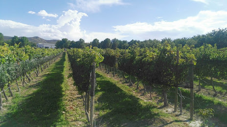
Photo
Where is located Rivero González
Rivero González — local attraction, which is located at Ramos Arizpe 7, Zona Centro, Parras de la Fuente, Coah., Mexico and belongs to the category — tourist attraction. Average visitor rating for this place — 4.6 (according to 278 ratings, information from open sources and relevant for 2022).
Exact location — Rivero González, marked on the map with a red marker.
You can get directions to Rivero González on the map from your location.
What else is interesting in Parras de la Fuente? You can see all the sights if you go to the city page.
Coordinates
Rivero González, Mexico coordinates in decimal format: latitude — 25.43566338387994, longitude — -102.15403237543626. When converted to degrees, minutes, seconds Rivero González has the following coordinates: 25°26′8.39 north latitude and -102°9′14.52 east longitude.
Nearby cities
The largest cities that are located nearby:
- Matamoros — 105 km
- Saltillo — 118 km
- Torreón — 123 km
- Gómez Palacio — 132 km
- Santa Catarina — 172 km
- Monclova — 178 km
- San Pedro Garza García — 178 km
- Monterrey — 187 km
- General Escobedo — 189 km
- San Nicolas de los Garza — 191 km
- Guadalupe — 193 km
- Apodaca — 201 km
- Fresnillo — 261 km
- Durango — 296 km
- Zacatecas — 299 km
- Nuevo Laredo — 342 km
- Laredo
 (United States) — 350 km
 - Ciudad Victoria — 361 km
- Soledad de Graciano Sánchez — 382 km
Distance to the capital
Distance to the capital (Mexico City) is about — 736 km.