
 Maureville
Samoëns
Gréning
Toulouse
Volx
Goudet
Méhoncourt
Saint-Hymer
Pontcarré
Maureville
Samoëns
Gréning
Toulouse
Volx
Goudet
Méhoncourt
Saint-Hymer
Pontcarré
PLAYMOBIL FunPark on the map, L'Haÿ-les-Roses, France
Photo
Where is located PLAYMOBIL FunPark
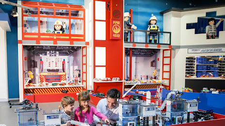
PLAYMOBIL FunPark — local attraction, which is located at ZA La Cerisaie, 24 All. des Jachères 22, 94260 Fresnes, France and belongs to the category — theme park. Average visitor rating for this place — 4.0 (according to 2266 ratings, information from open sources and relevant for 2022).
Exact location — PLAYMOBIL FunPark, marked on the map with a red marker.
You can get directions to PLAYMOBIL FunPark on the map from your location.
What else is interesting in L'Haÿ-les-Roses? You can see all the sights if you go to the city page.
Coordinates
PLAYMOBIL FunPark, France coordinates in decimal format: latitude — 48.754893049329034, longitude — 2.330687725220154. When converted to degrees, minutes, seconds PLAYMOBIL FunPark has the following coordinates: 48°45′17.61 north latitude and 2°19′50.48 east longitude.
Nearby cities
The largest cities that are located nearby:
- Boulogne-Billancourt — 10 km
- Orléans — 102 km
- Rouen — 115 km
- Amiens — 123 km
- Reims — 133 km
- Le Havre — 179 km
- Le Mans — 180 km
- Tours — 197 km
- Caen — 201 km
- Lille — 211 km
- Charleroi
 (Belgium) — 234 km
 - Namur (Belgium) — 258 km
- Dijon — 259 km
- Angers — 260 km
- Eastbourne
 (United Kingdom) — 262 km
 - Brussels (Belgium) — 269 km
- Metz — 280 km
- Nancy — 281 km
- Rennes — 305 km
Distance to the capital
Distance to the capital (Paris) is about — 11 km.