
 Bokamoso
Buysdorp
Xihosana
Ga-Sekororo
Ga-Rankuwa
Three Sisters
George
Haenertsburg
Polokwane
Bokamoso
Buysdorp
Xihosana
Ga-Sekororo
Ga-Rankuwa
Three Sisters
George
Haenertsburg
Polokwane
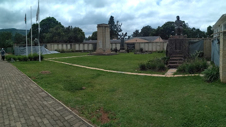
Greytown Battlefield Route on the map, Greytown, South Africa
Photo
Where is located Greytown Battlefield Route
Greytown Battlefield Route — local attraction, which is located at Greytown, 3250, South Africa and belongs to the category — historical landmark. Average visitor rating for this place — 3.9 (according to 71 rating, information from open sources and relevant for 2022).
Exact location — Greytown Battlefield Route, marked on the map with a red marker.
You can get directions to Greytown Battlefield Route on the map from your location.
What else is interesting in Greytown? You can see all the sights if you go to the city page.
Coordinates
Greytown Battlefield Route, South Africa coordinates in decimal format: latitude — -29.06607328166784, longitude — 30.59022202464198. When converted to degrees, minutes, seconds Greytown Battlefield Route has the following coordinates: -29°3′57.86 north latitude and 30°35′24.8 east longitude.
Nearby cities
The largest cities that are located nearby:
- Pietermaritzburg — 64 km
- Durban — 97 km
- Richards Bay — 142 km
- Vryheid — 144 km
- Newcastle — 159 km
- Manzini
 (Swaziland) — 292 km
 - Maseru
 (Lesotho) — 303 km
 - Bethal — 309 km
- Embalenhle — 316 km
- Nigel — 363 km
- Kroonstad — 365 km
- Vereeniging — 373 km
- Botshabelo — 375 km
- Springs — 377 km
- Vanderbijlpark — 378 km
- Middelburg — 381 km
- Virginia — 381 km
- Benoni — 390 km
- Boksburg — 391 km
Distance to the capital
Distance to the capital (Pretoria) is about — 439 km.