
 Maureville
Samoëns
Gréning
Toulouse
Volx
Goudet
Méhoncourt
Saint-Hymer
Pontcarré
Maureville
Samoëns
Gréning
Toulouse
Volx
Goudet
Méhoncourt
Saint-Hymer
Pontcarré
Plage Municipale Du Bourget Du Lac (Plage Municipale du Bourget-du-Lac) on the map, La Motte-Servolex, France
Photo
Where is located Plage Municipale Du Bourget Du Lac (Plage Municipale du Bourget-du-Lac)
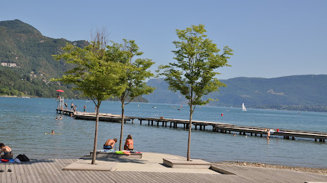
Plage Municipale Du Bourget Du Lac (Plage Municipale du Bourget-du-Lac) — local attraction, which is located at 223 Bd Ernest Coudurier, 73370 Le Bourget-du-Lac, France and belongs to the category — swimming lake. Average visitor rating for this place — 4.2 (according to 1697 ratings, information from open sources and relevant for 2022).
Exact location — Plage Municipale Du Bourget Du Lac (Plage Municipale du Bourget-du-Lac), marked on the map with a red marker.
You can get directions to Plage Municipale Du Bourget Du Lac (Plage Municipale du Bourget-du-Lac) on the map from your location.
What else is interesting in La Motte-Servolex? You can see all the sights if you go to the city page.
Coordinates
Plage Municipale Du Bourget Du Lac (Plage Municipale du Bourget-du-Lac), France coordinates in decimal format: latitude — 45.655437232926175, longitude — 5.861912825113316. When converted to degrees, minutes, seconds Plage Municipale Du Bourget Du Lac (Plage Municipale du Bourget-du-Lac) has the following coordinates: 45°39′19.57 north latitude and 5°51′42.89 east longitude.
Nearby cities
The largest cities that are located nearby:
- Grenoble — 47 km
- Geneva
 (Switzerland) — 70 km
 - Villeurbanne — 78 km
- Lyon — 82 km
- Saint-Étienne — 117 km
- Lausanne (Switzerland) — 117 km
- Turin
 (Italy) — 153 km
 - Besançon — 182 km
- Bern (Switzerland) — 191 km
- Dijon — 201 km
- Novara (Italy) — 214 km
- Clermont-Ferrand — 216 km
- Nimes — 229 km
- Aix-en-Provence — 231 km
- Nice — 236 km
- Basel (Switzerland) — 253 km
- Milan (Italy) — 257 km
- Marseille — 258 km
- Mulhouse — 262 km
Distance to the capital
Distance to the capital (Paris) is about — 444 km.