
 Maureville
Samoëns
Gréning
Toulouse
Volx
Goudet
Méhoncourt
Saint-Hymer
Pontcarré
Maureville
Samoëns
Gréning
Toulouse
Volx
Goudet
Méhoncourt
Saint-Hymer
Pontcarré
Ile de Loisirs de Cergy-Pontoise on the map, Vauréal, France
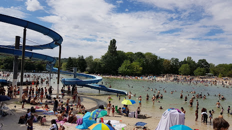
Photo
Where is located Ile de Loisirs de Cergy-Pontoise
Ile de Loisirs de Cergy-Pontoise — local attraction, which is located at 1 Rue des Étangs, 95000 Neuville-sur-Oise, France and belongs to the category — amusement center. Average visitor rating for this place — 4.2 (according to 5685 ratings, information from open sources and relevant for 2022).
Exact location — Ile de Loisirs de Cergy-Pontoise, marked on the map with a red marker.
You can get directions to Ile de Loisirs de Cergy-Pontoise on the map from your location.
What else is interesting in Vauréal? You can see all the sights if you go to the city page.
Coordinates
Ile de Loisirs de Cergy-Pontoise, France coordinates in decimal format: latitude — 49.030456424314615, longitude — 2.0485211252299105. When converted to degrees, minutes, seconds Ile de Loisirs de Cergy-Pontoise has the following coordinates: 49°1′49.64 north latitude and 2°2′54.68 east longitude.
Nearby cities
The largest cities that are located nearby:
- Boulogne-Billancourt — 26 km
- Rouen — 81 km
- Amiens — 98 km
- Orléans — 125 km
- Le Havre — 147 km
- Reims — 147 km
- Caen — 174 km
- Le Mans — 176 km
- Lille — 191 km
- Tours — 207 km
- Eastbourne
 (United Kingdom) — 227 km
 - Charleroi
 (Belgium) — 229 km
 - Namur (Belgium) — 256 km
- Angers — 258 km
- Brussels (Belgium) — 259 km
- Crawley (United Kingdom) — 276 km
- Gillingham (United Kingdom) — 280 km
- Rennes — 291 km
- Southend-on-Sea (United Kingdom) — 293 km
Distance to the capital
Distance to the capital (Paris) is about — 29 km.