
 Maureville
Samoëns
Gréning
Toulouse
Volx
Goudet
Méhoncourt
Saint-Hymer
Pontcarré
Maureville
Samoëns
Gréning
Toulouse
Volx
Goudet
Méhoncourt
Saint-Hymer
Pontcarré
Église Saint-Rémi on the map, Stiring-Wendel, France
Photo
Where is located Église Saint-Rémi
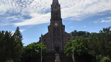
Église Saint-Rémi — local attraction, which is located at 15 Pl. Jeanne d'Arc, 57600 Forbach, France and belongs to the category — church. Average visitor rating for this place — 4.3 (according to 149 ratings, information from open sources and relevant for 2022).
Exact location — Église Saint-Rémi, marked on the map with a red marker.
You can get directions to Église Saint-Rémi on the map from your location.
What else is interesting in Stiring-Wendel? You can see all the sights if you go to the city page.
Coordinates
Église Saint-Rémi, France coordinates in decimal format: latitude — 49.17567805830565, longitude — 6.932045933251816. When converted to degrees, minutes, seconds Église Saint-Rémi has the following coordinates: 49°10′32.44 north latitude and 6°55′55.37 east longitude.
Nearby cities
The largest cities that are located nearby:
- Saarbrücken
 (Germany) — 6 km
 - Metz — 55 km
- Trier (Germany) — 64 km
- Nancy — 78 km
- Strasbourg — 92 km
- Karlsruhe (Germany) — 109 km
- Ludwigshafen (Germany) — 113 km
- Mannheim (Germany) — 115 km
- Heidelberg (Germany) — 127 km
- Mainz (Germany) — 128 km
- Pforzheim (Germany) — 133 km
- Wiesbaden (Germany) — 134 km
- Koblenz (Germany) — 136 km
- Darmstadt (Germany) — 143 km
- Freiburg (Germany) — 149 km
- Frankfurt (Germany) — 160 km
- Mulhouse — 163 km
- Offenbach (Germany) — 164 km
- Heilbronn (Germany) — 165 km
Distance to the capital
Distance to the capital (Paris) is about — 336 km.