
 Gilserberg
Berlin
Bordesholm
Bechtolsheim
Aub
Triptis
Heppenheim
Biblis
Angermünde
Gilserberg
Berlin
Bordesholm
Bechtolsheim
Aub
Triptis
Heppenheim
Biblis
Angermünde
Couvent franciscain de Wiedenbrück on the map, Rheda-Wiedenbrück, Germany
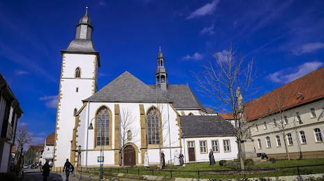
Photo
Where is located Couvent franciscain de Wiedenbrück
Couvent franciscain de Wiedenbrück — local attraction, which is located at Mönchstraße 19, 33378 Rheda-Wiedenbrück, Germany and belongs to the category — monastery. Average visitor rating for this place — 4.5 (according to 50 ratings, information from open sources and relevant for 2022).
Exact location — Couvent franciscain de Wiedenbrück, marked on the map with a red marker.
You can get directions to Couvent franciscain de Wiedenbrück on the map from your location.
What else is interesting in Rheda-Wiedenbrück? You can see all the sights if you go to the city page.
Coordinates
Couvent franciscain de Wiedenbrück, Germany coordinates in decimal format: latitude — 51.83602264695052, longitude — 8.314070425331522. When converted to degrees, minutes, seconds Couvent franciscain de Wiedenbrück has the following coordinates: 51°50′9.68 north latitude and 8°18′50.65 east longitude.
Nearby cities
The largest cities that are located nearby:
- Bielefeld — 26 km
- Paderborn — 34 km
- Hamm — 38 km
- Münster — 48 km
- Osnabrück — 51 km
- Dortmund — 68 km
- Hagen — 78 km
- Witten — 79 km
- Recklinghausen — 80 km
- Herne — 83 km
- Bochum — 85 km
- Gelsenkirchen — 91 km
- Essen — 99 km
- Bottrop — 100 km
- Kassel — 101 km
- Wuppertal — 103 km
- Enschede
 (Netherlands) — 104 km
 - Oberhausen — 106 km
- Remscheid — 107 km
Distance to the capital
Distance to the capital (Berlin) is about — 355 km.