
 Maureville
Samoëns
Gréning
Toulouse
Volx
Goudet
Méhoncourt
Saint-Hymer
Pontcarré
Maureville
Samoëns
Gréning
Toulouse
Volx
Goudet
Méhoncourt
Saint-Hymer
Pontcarré
Parque Natural Regional Scarpe-Escaut on the map, Bruay-sur-l'Escaut, France
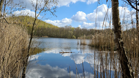
Photo
Where is located Parque Natural Regional Scarpe-Escaut
Parque Natural Regional Scarpe-Escaut — local attraction, which is located at 357 Rue Notre Dame d'Amour, 59230 Saint-Amand-les-Eaux, France and belongs to the category — nature preserve. Average visitor rating for this place — 4.2 (according to 6798 ratings, information from open sources and relevant for 2022).
Exact location — Parque Natural Regional Scarpe-Escaut, marked on the map with a red marker.
You can get directions to Parque Natural Regional Scarpe-Escaut on the map from your location.
What else is interesting in Bruay-sur-l'Escaut? You can see all the sights if you go to the city page.
Coordinates
Parque Natural Regional Scarpe-Escaut, France coordinates in decimal format: latitude — 50.396195311864616, longitude — 3.537098144591818. When converted to degrees, minutes, seconds Parque Natural Regional Scarpe-Escaut has the following coordinates: 50°23′46.3 north latitude and 3°32′13.55 east longitude.
Nearby cities
The largest cities that are located nearby:
- Lille — 42 km
- Charleroi
 (Belgium) — 64 km
 - Brussels (Belgium) — 76 km
- Namur (Belgium) — 94 km
- Amiens — 104 km
- Antwerp (Belgium) — 109 km
- Reims — 131 km
- Liège (Belgium) — 146 km
- Breda
 (Netherlands) — 156 km
 - Maastricht (Netherlands) — 158 km
- Tilburg (Netherlands) — 167 km
- Dordrecht (Netherlands) — 175 km
- Eindhoven (Netherlands) — 176 km
- Rotterdam (Netherlands) — 181 km
- Aachen
 (Germany) — 183 km
 - 's-Hertogenbosch (Netherlands) — 188 km
- The Hague (Netherlands) — 192 km
- Zoetermeer (Netherlands) — 195 km
- Boulogne-Billancourt — 196 km
Distance to the capital
Distance to the capital (Paris) is about — 191 km.