
 Zelfana
Balloul
أحمد سالم كركرة
Ouargla Province
Boumaiza
Constantine
Frane
Ain Arko
Corso
Zelfana
Balloul
أحمد سالم كركرة
Ouargla Province
Boumaiza
Constantine
Frane
Ain Arko
Corso
Villa Abdullatif (Villa Abd El Tif) on the map, Algiers, Algeria
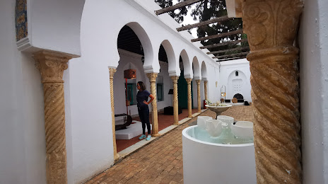
Photo
Where is located Villa Abdullatif (Villa Abd El Tif)
Villa Abdullatif (Villa Abd El Tif) — local attraction, which is located at Rue Du Dr Laveran, Algiers, Algeria and belongs to the category — historical place. Average visitor rating for this place — 4.4 (according to 104 ratings, information from open sources and relevant for 2022).
Exact location — Villa Abdullatif (Villa Abd El Tif), marked on the map with a red marker.
You can get directions to Villa Abdullatif (Villa Abd El Tif) on the map from your location.
What else is interesting in Algiers? You can see all the sights if you go to the city page.
Coordinates
Villa Abdullatif (Villa Abd El Tif), Algeria coordinates in decimal format: latitude — 36.744824493017674, longitude — 3.072865224837731. When converted to degrees, minutes, seconds Villa Abdullatif (Villa Abd El Tif) has the following coordinates: 36°44′41.37 north latitude and 3°4′22.31 east longitude.
Nearby cities
The largest cities that are located nearby:
- Médéa — 61 km
- Chlef — 167 km
- Bou Arreridj Bordj — 170 km
- Bejaia — 177 km
- M'Sila — 180 km
- Setif — 220 km
- Relizane — 252 km
- Batna — 310 km
- Palma
 (Spain) — 312 km
 - Constantine — 319 km
- Laghouat — 328 km
- Saida — 338 km
- Skikda — 340 km
- Oran — 351 km
- Cartagena (Spain) — 367 km
- Sidi Bel Abbes — 376 km
- Murcia (Spain) — 389 km
- Guelma — 391 km
- Annaba — 417 km