
 Zelfana
Balloul
أحمد سالم كركرة
Ouargla Province
Boumaiza
Constantine
Frane
Ain Arko
Corso
Zelfana
Balloul
أحمد سالم كركرة
Ouargla Province
Boumaiza
Constantine
Frane
Ain Arko
Corso
Beyrouth Parc on the map, Algiers, Algeria
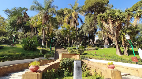
Photo
Where is located Beyrouth Parc
Beyrouth Parc — local attraction, which is located at 94 Bd Colonel Krim Belkacem, Alger Ctre, Algeria and belongs to the category — park. Average visitor rating for this place — 4.4 (according to 174 ratings, information from open sources and relevant for 2022).
Exact location — Beyrouth Parc, marked on the map with a red marker.
You can get directions to Beyrouth Parc on the map from your location.
What else is interesting in Algiers? You can see all the sights if you go to the city page.
Coordinates
Beyrouth Parc, Algeria coordinates in decimal format: latitude — 36.76828420760891, longitude — 3.046601424743824. When converted to degrees, minutes, seconds Beyrouth Parc has the following coordinates: 36°46′5.82 north latitude and 3°2′47.77 east longitude.
Nearby cities
The largest cities that are located nearby:
- Sidi M'Hamed — 8 km
- Médéa — 63 km
- Bou Arreridj Bordj — 162 km
- Bejaia — 170 km
- M'Sila — 172 km
- Chlef — 173 km
- Setif — 211 km
- Relizane — 258 km
- Batna — 302 km
- Constantine — 311 km
- Palma
 (Spain) — 316 km
 - Laghouat — 326 km
- Skikda — 333 km
- Saida — 343 km
- Oran — 358 km
- Cartagena (Spain) — 375 km
- Sidi Bel Abbes — 382 km
- Guelma — 383 km
- Murcia (Spain) — 397 km