 Warner Robins
Wantagh
Bethel
Misty Hill Farm
United States
Wakonda Beach (R33) Airport
Wilmington
Poland
Miami International Airport
Warner Robins
Wantagh
Bethel
Misty Hill Farm
United States
Wakonda Beach (R33) Airport
Wilmington
Poland
Miami International Airport
Black Mountain Lookout Trailhead on the map, Sheridan, United States
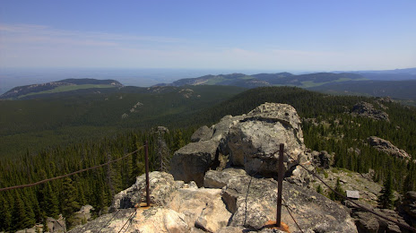
Photo
Where is located Black Mountain Lookout Trailhead
Black Mountain Lookout Trailhead — local attraction, which is located at FSR 222, Dayton, WY 82836, United States and belongs to the category — hiking area. Average visitor rating for this place — 5.0 (according to 8 ratings, information from open sources and relevant for 2022).
Exact location — Black Mountain Lookout Trailhead, marked on the map with a red marker.
You can get directions to Black Mountain Lookout Trailhead on the map from your location.
What else is interesting in Sheridan? You can see all the sights if you go to the city page.
Coordinates
Black Mountain Lookout Trailhead, United States coordinates in decimal format: latitude — 44.73809058446458, longitude — -107.38798437491725. When converted to degrees, minutes, seconds Black Mountain Lookout Trailhead has the following coordinates: 44°44′17.13 north latitude and -107°23′16.74 east longitude.
Nearby cities
The largest cities that are located nearby:
- Fort Collins — 491 km
- Thornton — 570 km
- Westminster — 572 km
- Arvada — 575 km
- Denver — 584 km
- Lakewood — 585 km
- Aurora — 589 km
- Salt Lake City — 608 km
- West Valley City — 620 km
- West Jordan — 624 km
- Provo — 642 km
- Regina
 (Canada) — 647 km
 - Colorado Springs — 684 km
- Pueblo — 752 km
- Boise — 752 km
- Saskatoon (Canada) — 811 km
- Sioux Falls — 831 km
- Spokane — 841 km
- Calgary (Canada) — 850 km
Distance to the capital
Distance to the capital (Washington) is about — 2582 km.