
 Maureville
Samoëns
Gréning
Toulouse
Volx
Goudet
Méhoncourt
Saint-Hymer
Pontcarré
Maureville
Samoëns
Gréning
Toulouse
Volx
Goudet
Méhoncourt
Saint-Hymer
Pontcarré
Parc de Déomas on the map, Annonay, France
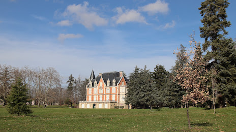
Photo
Where is located Parc de Déomas
Parc de Déomas — local attraction, which is located at 32 Rue Mathieu Duret, 07100 Annonay, France and belongs to the category — park. Average visitor rating for this place — 4.3 (according to 220 ratings, information from open sources and relevant for 2022).
Exact location — Parc de Déomas, marked on the map with a red marker.
You can get directions to Parc de Déomas on the map from your location.
What else is interesting in Annonay? You can see all the sights if you go to the city page.
Coordinates
Parc de Déomas, France coordinates in decimal format: latitude — 45.25491891609037, longitude — 4.673170197916964. When converted to degrees, minutes, seconds Parc de Déomas has the following coordinates: 45°15′17.71 north latitude and 4°40′23.41 east longitude.
Nearby cities
The largest cities that are located nearby:
- Saint-Étienne — 31 km
- Lyon — 59 km
- Villeurbanne — 61 km
- Grenoble — 83 km
- Clermont-Ferrand — 136 km
- Geneva
 (Switzerland) — 155 km
 - Nimes — 157 km
- Montpellier — 191 km
- Aix-en-Provence — 199 km
- Lausanne (Switzerland) — 206 km
- Marseille — 222 km
- Dijon — 232 km
- Turin
 (Italy) — 237 km
 - Besançon — 243 km
- Toulon — 255 km
- Nice — 268 km
- Limoges — 271 km
- Bern (Switzerland) — 282 km
- Novara (Italy) — 308 km
Distance to the capital
Distance to the capital (Paris) is about — 437 km.