
 Maureville
Samoëns
Gréning
Toulouse
Volx
Goudet
Méhoncourt
Saint-Hymer
Pontcarré
Maureville
Samoëns
Gréning
Toulouse
Volx
Goudet
Méhoncourt
Saint-Hymer
Pontcarré
Château de Villiers-le-Bâcle on the map, Palaiseau, France
Photo
Where is located Château de Villiers-le-Bâcle
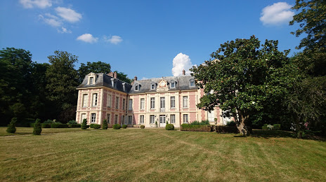
Château de Villiers-le-Bâcle — local attraction, which is located at All. du Château, 91190 Villiers-le-Bâcle, France and belongs to the category — castle. Average visitor rating for this place — 4.6 (according to 25 ratings, information from open sources and relevant for 2022).
Exact location — Château de Villiers-le-Bâcle, marked on the map with a red marker.
You can get directions to Château de Villiers-le-Bâcle on the map from your location.
What else is interesting in Palaiseau? You can see all the sights if you go to the city page.
Coordinates
Château de Villiers-le-Bâcle, France coordinates in decimal format: latitude — 48.72401679093548, longitude — 2.128326025124475. When converted to degrees, minutes, seconds Château de Villiers-le-Bâcle has the following coordinates: 48°43′26.46 north latitude and 2°7′41.97 east longitude.
Nearby cities
The largest cities that are located nearby:
- Boulogne-Billancourt — 14 km
- Orléans — 93 km
- Rouen — 115 km
- Amiens — 130 km
- Reims — 142 km
- Le Mans — 170 km
- Le Havre — 176 km
- Tours — 187 km
- Caen — 196 km
- Lille — 219 km
- Charleroi
 (Belgium) — 243 km
 - Angers — 250 km
- Dijon — 260 km
- Eastbourne
 (United Kingdom) — 265 km
 - Namur (Belgium) — 268 km
- Brussels (Belgium) — 278 km
- Nancy — 287 km
- Metz — 288 km
- Rennes — 297 km
Distance to the capital
Distance to the capital (Paris) is about — 22 km.