
 Maureville
Samoëns
Gréning
Toulouse
Volx
Goudet
Méhoncourt
Saint-Hymer
Pontcarré
Maureville
Samoëns
Gréning
Toulouse
Volx
Goudet
Méhoncourt
Saint-Hymer
Pontcarré
Castle of Flers on the map, Villeneuve-d'Ascq, France
Photo
Where is located Castle of Flers
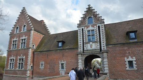
Castle of Flers — local attraction, which is located at Chem. du Chat Botte, 59650 Villeneuve-d'Ascq, France and belongs to the category — museum. Average visitor rating for this place — 4.5 (according to 99 ratings, information from open sources and relevant for 2022).
Exact location — Castle of Flers, marked on the map with a red marker.
You can get directions to Castle of Flers on the map from your location.
What else is interesting in Villeneuve-d'Ascq? You can see all the sights if you go to the city page.
Coordinates
Castle of Flers, France coordinates in decimal format: latitude — 50.63594295592714, longitude — 3.132822425192963. When converted to degrees, minutes, seconds Castle of Flers has the following coordinates: 50°38′9.39 north latitude and 3°7′58.16 east longitude.
Nearby cities
The largest cities that are located nearby:
- Lille — 6 km
- Brussels
 (Belgium) — 88 km
 - Charleroi (Belgium) — 95 km
- Amiens — 101 km
- Antwerp (Belgium) — 109 km
- Namur (Belgium) — 123 km
- Breda
 (Netherlands) — 154 km
 - Reims — 164 km
- Dordrecht (Netherlands) — 169 km
- Tilburg (Netherlands) — 169 km
- Rotterdam (Netherlands) — 170 km
- Liège (Belgium) — 171 km
- The Hague (Netherlands) — 178 km
- Maastricht (Netherlands) — 180 km
- Zoetermeer (Netherlands) — 184 km
- Eindhoven (Netherlands) — 184 km
- 's-Hertogenbosch (Netherlands) — 190 km
- Leiden (Netherlands) — 193 km
- Southend-on-Sea
 (United Kingdom) — 196 km
Distance to the capital
Distance to the capital (Paris) is about — 206 km.