
 Maureville
Samoëns
Gréning
Toulouse
Volx
Goudet
Méhoncourt
Saint-Hymer
Pontcarré
Maureville
Samoëns
Gréning
Toulouse
Volx
Goudet
Méhoncourt
Saint-Hymer
Pontcarré
on the map, Le Bourget, France
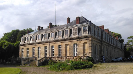
Photo
Where is located
— local attraction, which is located at 7 Rond-Point de la Victoire, 95400 Arnouville, France and belongs to the category — castle. Average visitor rating for this place — 4.4 (according to 5 ratings, information from open sources and relevant for 2022).
Exact location — , marked on the map with a red marker.
You can get directions to on the map from your location.
What else is interesting in Le Bourget? You can see all the sights if you go to the city page.
Coordinates
, France coordinates in decimal format: latitude — 48.979800071292495, longitude — 2.4186823251335308. When converted to degrees, minutes, seconds has the following coordinates: 48°58′47.28 north latitude and 2°25′7.26 east longitude.
Nearby cities
The largest cities that are located nearby:
- Boulogne-Billancourt — 17 km
- Amiens — 106 km
- Rouen — 111 km
- Orléans — 121 km
- Reims — 121 km
- Le Havre — 177 km
- Lille — 192 km
- Le Mans — 194 km
- Caen — 204 km
- Tours — 215 km
- Charleroi
 (Belgium) — 216 km
 - Namur (Belgium) — 241 km
- Brussels (Belgium) — 251 km
- Eastbourne
 (United Kingdom) — 252 km
 - Dijon — 265 km
- Metz — 272 km
- Angers — 275 km
- Nancy — 276 km
- Antwerp (Belgium) — 287 km
Distance to the capital
Distance to the capital (Paris) is about — 15 km.