
 Maureville
Samoëns
Gréning
Toulouse
Volx
Goudet
Méhoncourt
Saint-Hymer
Pontcarré
Maureville
Samoëns
Gréning
Toulouse
Volx
Goudet
Méhoncourt
Saint-Hymer
Pontcarré
Collégiale Notre-Dame-du-Fort d'Étampes on the map, Étampes, France
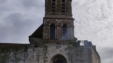
Photo
Where is located Collégiale Notre-Dame-du-Fort d'Étampes
Collégiale Notre-Dame-du-Fort d'Étampes — local attraction, which is located at 24 Rue du Cloître Notre Dame, 91150 Étampes, France and belongs to the category — church. Average visitor rating for this place — 4.8 (according to 5 ratings, information from open sources and relevant for 2022).
Exact location — Collégiale Notre-Dame-du-Fort d'Étampes, marked on the map with a red marker.
You can get directions to Collégiale Notre-Dame-du-Fort d'Étampes on the map from your location.
What else is interesting in Étampes? You can see all the sights if you go to the city page.
Coordinates
Collégiale Notre-Dame-du-Fort d'Étampes, France coordinates in decimal format: latitude — 48.434956387964945, longitude — 2.1641125251142994. When converted to degrees, minutes, seconds Collégiale Notre-Dame-du-Fort d'Étampes has the following coordinates: 48°26′5.84 north latitude and 2°9′50.81 east longitude.
Nearby cities
The largest cities that are located nearby:
- Boulogne-Billancourt — 45 km
- Orléans — 62 km
- Rouen — 135 km
- Le Mans — 153 km
- Tours — 160 km
- Amiens — 162 km
- Reims — 163 km
- Le Havre — 188 km
- Caen — 201 km
- Angers — 229 km
- Dijon — 248 km
- Lille — 251 km
- Charleroi
 (Belgium) — 271 km
 - Rennes — 286 km
- Eastbourne
 (United Kingdom) — 289 km
 - Namur (Belgium) — 295 km
- Nancy — 295 km
- Limoges — 296 km
- Metz — 300 km
Distance to the capital
Distance to the capital (Paris) is about — 49 km.