
 Maureville
Samoëns
Gréning
Toulouse
Volx
Goudet
Méhoncourt
Saint-Hymer
Pontcarré
Maureville
Samoëns
Gréning
Toulouse
Volx
Goudet
Méhoncourt
Saint-Hymer
Pontcarré
Clichy Bridge on the map, Asnières-sur-Seine, France
Photo
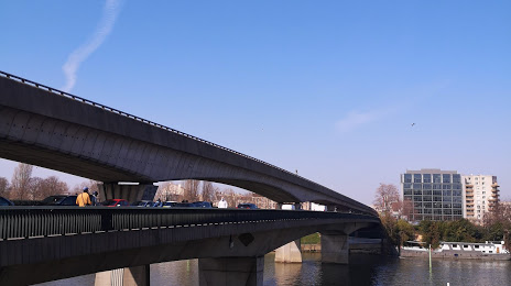
Where is located Clichy Bridge
Clichy Bridge — local attraction, which is located at Pont de Clichy, 92110 Clichy, France and belongs to the category — bridge. Average visitor rating for this place — 3.4 (according to 73 ratings, information from open sources and relevant for 2022).
Exact location — Clichy Bridge, marked on the map with a red marker.
You can get directions to Clichy Bridge on the map from your location.
What else is interesting in Asnières-sur-Seine? You can see all the sights if you go to the city page.
Coordinates
Clichy Bridge, France coordinates in decimal format: latitude — 48.90959982172305, longitude — 2.299422225131053. When converted to degrees, minutes, seconds Clichy Bridge has the following coordinates: 48°54′34.56 north latitude and 2°17′57.92 east longitude.
Nearby cities
The largest cities that are located nearby:
- Boulogne-Billancourt — 9 km
- Rouen — 103 km
- Amiens — 108 km
- Orléans — 115 km
- Reims — 132 km
- Le Havre — 169 km
- Le Mans — 184 km
- Caen — 194 km
- Lille — 197 km
- Tours — 206 km
- Charleroi
 (Belgium) — 225 km
 - Eastbourne
 (United Kingdom) — 248 km
 - Namur (Belgium) — 250 km
- Brussels (Belgium) — 258 km
- Angers — 266 km
- Dijon — 271 km
- Metz — 282 km
- Nancy — 286 km
- Antwerp (Belgium) — 294 km
Distance to the capital
Distance to the capital (Paris) is about — 7 km.