
 Maureville
Samoëns
Gréning
Toulouse
Volx
Goudet
Méhoncourt
Saint-Hymer
Pontcarré
Maureville
Samoëns
Gréning
Toulouse
Volx
Goudet
Méhoncourt
Saint-Hymer
Pontcarré
Lac Vert on the map, Mérignac, France
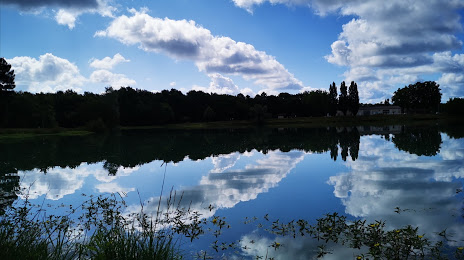
Photo
Where is located Lac Vert
Lac Vert — local attraction, which is located at no data and belongs to the category — -. Average visitor rating for this place — 4.5 (according to 122 ratings, information from open sources and relevant for 2022).
Exact location — Lac Vert, marked on the map with a red marker.
You can get directions to Lac Vert on the map from your location.
What else is interesting in Mérignac? You can see all the sights if you go to the city page.
Coordinates
Lac Vert, France coordinates in decimal format: latitude — 44.83000913345271, longitude — -0.6840089343058608. When converted to degrees, minutes, seconds Lac Vert has the following coordinates: 44°49′48.03 north latitude and -0°41′2.43 east longitude.
Nearby cities
The largest cities that are located nearby:
- Bordeaux — 6 km
- Limoges — 184 km
- San Sebastián
 (Spain) — 200 km
 - Toulouse — 217 km
- Pamplona (Spain) — 239 km
- Bilbao (Spain) — 253 km
- Nantes — 271 km
- Vitoria-Gasteiz (Spain) — 274 km
- Angers — 291 km
- Santander (Spain) — 296 km
- Tours — 299 km
- Logroño (Spain) — 301 km
- Clermont-Ferrand — 307 km
- Zaragoza (Spain) — 354 km
- Le Mans — 355 km
- Rennes — 370 km
- Burgos (Spain) — 372 km
- Lleida (Spain) — 372 km
- Perpignan — 374 km
Distance to the capital
Distance to the capital (Paris) is about — 504 km.