
 Maureville
Samoëns
Gréning
Toulouse
Volx
Goudet
Méhoncourt
Saint-Hymer
Pontcarré
Maureville
Samoëns
Gréning
Toulouse
Volx
Goudet
Méhoncourt
Saint-Hymer
Pontcarré
Église Saint-Jacques-le-Majeur de Nice on the map, Nice, France
Photo
Where is located Église Saint-Jacques-le-Majeur de Nice
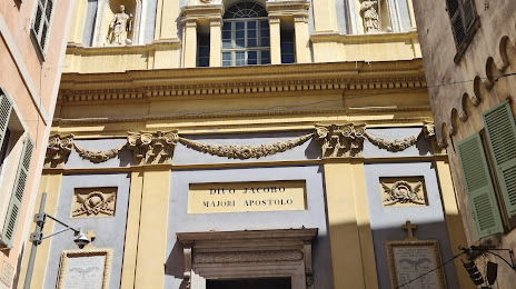
Église Saint-Jacques-le-Majeur de Nice — local attraction, which is located at 1 Rue du Jésus, 06300 Nice, France and belongs to the category — catholic church. Average visitor rating for this place — 4.4 (according to 109 ratings, information from open sources and relevant for 2022).
Exact location — Église Saint-Jacques-le-Majeur de Nice, marked on the map with a red marker.
You can get directions to Église Saint-Jacques-le-Majeur de Nice on the map from your location.
What else is interesting in Nice? You can see all the sights if you go to the city page.
Coordinates
Église Saint-Jacques-le-Majeur de Nice, France coordinates in decimal format: latitude — 43.69670209402001, longitude — 7.277282224953997. When converted to degrees, minutes, seconds Église Saint-Jacques-le-Majeur de Nice has the following coordinates: 43°41′48.13 north latitude and 7°16′38.22 east longitude.
Nearby cities
The largest cities that are located nearby:
- Toulon — 126 km
- Aix-en-Provence — 147 km
- Genoa
 (Italy) — 154 km
 - Turin (Italy) — 154 km
- Marseille — 159 km
- Grenoble — 203 km
- Novara (Italy) — 219 km
- Nimes — 232 km
- Milan (Italy) — 245 km
- Livorno (Italy) — 245 km
- Monza (Italy) — 259 km
- Parma (Italy) — 269 km
- Montpellier — 271 km
- Geneva
 (Switzerland) — 288 km
 - Bergamo (Italy) — 288 km
- Villeurbanne — 292 km
- Saint-Étienne — 294 km
- Lyon — 294 km
- Brescia (Italy) — 305 km
Distance to the capital
Distance to the capital (Paris) is about — 687 km.