
 Maureville
Samoëns
Gréning
Toulouse
Volx
Goudet
Méhoncourt
Saint-Hymer
Pontcarré
Maureville
Samoëns
Gréning
Toulouse
Volx
Goudet
Méhoncourt
Saint-Hymer
Pontcarré
Chateau de Goussainville-Vieux Pays on the map, Goussainville, France
Photo
Where is located Chateau de Goussainville-Vieux Pays
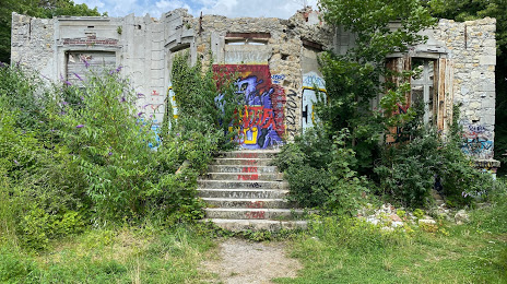
Chateau de Goussainville-Vieux Pays — local attraction, which is located at 4 Pl. Hyacinthe Drujon, 95190 Goussainville, France and belongs to the category — historical landmark. Average visitor rating for this place — 4.3 (according to 7 ratings, information from open sources and relevant for 2022).
Exact location — Chateau de Goussainville-Vieux Pays, marked on the map with a red marker.
You can get directions to Chateau de Goussainville-Vieux Pays on the map from your location.
What else is interesting in Goussainville? You can see all the sights if you go to the city page.
Coordinates
Chateau de Goussainville-Vieux Pays, France coordinates in decimal format: latitude — 49.01296299472801, longitude — 2.463720625134714. When converted to degrees, minutes, seconds Chateau de Goussainville-Vieux Pays has the following coordinates: 49°0′46.67 north latitude and 2°27′49.39 east longitude.
Nearby cities
The largest cities that are located nearby:
- Boulogne-Billancourt — 27 km
- Amiens — 96 km
- Rouen — 109 km
- Reims — 115 km
- Orléans — 131 km
- Le Havre — 177 km
- Lille — 181 km
- Le Mans — 203 km
- Caen — 206 km
- Charleroi
 (Belgium) — 206 km
 - Tours — 225 km
- Namur (Belgium) — 232 km
- Brussels (Belgium) — 240 km
- Eastbourne
 (United Kingdom) — 245 km
 - Metz — 268 km
- Dijon — 270 km
- Nancy — 274 km
- Antwerp (Belgium) — 277 km
- Liège (Belgium) — 281 km
Distance to the capital
Distance to the capital (Paris) is about — 19 km.