
 Maureville
Samoëns
Gréning
Toulouse
Volx
Goudet
Méhoncourt
Saint-Hymer
Pontcarré
Maureville
Samoëns
Gréning
Toulouse
Volx
Goudet
Méhoncourt
Saint-Hymer
Pontcarré
Le parc de la Plage-Bleue on the map, Créteil, France
Photo
Where is located Le parc de la Plage-Bleue
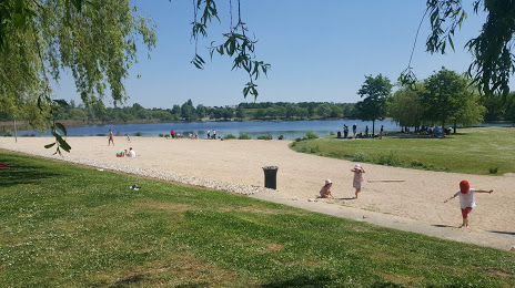
Le parc de la Plage-Bleue — local attraction, which is located at Route départementale, 29 Avenue de Valenton, 94460 Valenton, France and belongs to the category — park. Average visitor rating for this place — 4.2 (according to 2114 ratings, information from open sources and relevant for 2022).
Exact location — Le parc de la Plage-Bleue, marked on the map with a red marker.
You can get directions to Le parc de la Plage-Bleue on the map from your location.
What else is interesting in Créteil? You can see all the sights if you go to the city page.
Coordinates
Le parc de la Plage-Bleue, France coordinates in decimal format: latitude — 48.754463212366716, longitude — 2.4644807251255636. When converted to degrees, minutes, seconds Le parc de la Plage-Bleue has the following coordinates: 48°45′16.07 north latitude and 2°27′52.13 east longitude.
Nearby cities
The largest cities that are located nearby:
- Boulogne-Billancourt — 17 km
- Orléans — 106 km
- Rouen — 121 km
- Amiens — 123 km
- Reims — 125 km
- Le Havre — 186 km
- Le Mans — 188 km
- Tours — 203 km
- Lille — 208 km
- Caen — 209 km
- Charleroi
 (Belgium) — 227 km
 - Namur (Belgium) — 252 km
- Dijon — 253 km
- Brussels (Belgium) — 263 km
- Eastbourne
 (United Kingdom) — 266 km
 - Angers — 268 km
- Metz — 272 km
- Nancy — 272 km
- Liège (Belgium) — 299 km
Distance to the capital
Distance to the capital (Paris) is about — 14 km.