
 Maureville
Samoëns
Gréning
Toulouse
Volx
Goudet
Méhoncourt
Saint-Hymer
Pontcarré
Maureville
Samoëns
Gréning
Toulouse
Volx
Goudet
Méhoncourt
Saint-Hymer
Pontcarré
Beaune-Semblançay Garden on the map, Tours, France
Photo
Where is located Beaune-Semblançay Garden
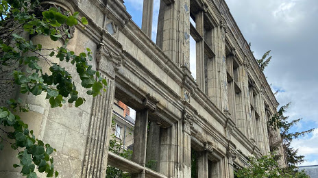
Beaune-Semblançay Garden — local attraction, which is located at Jard de Beaune Semblancay, 37000 Tours, France and belongs to the category — garden. Average visitor rating for this place — 4.4 (according to 25 ratings, information from open sources and relevant for 2022).
Exact location — Beaune-Semblançay Garden, marked on the map with a red marker.
You can get directions to Beaune-Semblançay Garden on the map from your location.
What else is interesting in Tours? You can see all the sights if you go to the city page.
Coordinates
Beaune-Semblançay Garden, France coordinates in decimal format: latitude — 47.39511126535883, longitude — 0.6873500250780269. When converted to degrees, minutes, seconds Beaune-Semblançay Garden has the following coordinates: 47°23′42.4 north latitude and 0°41′14.46 east longitude.
Nearby cities
The largest cities that are located nearby:
- Le Mans — 77 km
- Angers — 94 km
- Orléans — 107 km
- Nantes — 169 km
- Limoges — 178 km
- Rennes — 192 km
- Boulogne-Billancourt — 196 km
- Caen — 212 km
- Rouen — 229 km
- Le Havre — 236 km
- Clermont-Ferrand — 257 km
- Amiens — 299 km
- Bordeaux — 299 km
- Reims — 318 km
- Dijon — 327 km
- Saint-Étienne — 359 km
- Lyon — 367 km
- Villeurbanne — 371 km
- Eastbourne
 (United Kingdom) — 374 km
Distance to the capital
Distance to the capital (Paris) is about — 204 km.