
 Maureville
Samoëns
Gréning
Toulouse
Volx
Goudet
Méhoncourt
Saint-Hymer
Pontcarré
Maureville
Samoëns
Gréning
Toulouse
Volx
Goudet
Méhoncourt
Saint-Hymer
Pontcarré
Musée de Gergovie on the map, Clermont-Ferrand, France
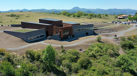
Photo
Where is located Musée de Gergovie
Musée de Gergovie — local attraction, which is located at Plt de Gergovie, 63670 La Roche-Blanche, France and belongs to the category — museum. Average visitor rating for this place — 4.3 (according to 314 ratings, information from open sources and relevant for 2022).
Exact location — Musée de Gergovie, marked on the map with a red marker.
You can get directions to Musée de Gergovie on the map from your location.
What else is interesting in Clermont-Ferrand? You can see all the sights if you go to the city page.
Coordinates
Musée de Gergovie, France coordinates in decimal format: latitude — 45.71973582642941, longitude — 3.1268630250208607. When converted to degrees, minutes, seconds Musée de Gergovie has the following coordinates: 45°43′11.05 north latitude and 3°7′36.71 east longitude.
Nearby cities
The largest cities that are located nearby:
- Saint-Étienne — 108 km
- Lyon — 135 km
- Villeurbanne — 139 km
- Limoges — 141 km
- Grenoble — 216 km
- Dijon — 225 km
- Nimes — 237 km
- Geneva
 (Switzerland) — 238 km
 - Montpellier — 248 km
- Orléans — 251 km
- Tours — 254 km
- Besançon — 273 km
- Toulouse — 274 km
- Lausanne (Switzerland) — 282 km
- Bordeaux — 306 km
- Aix-en-Provence — 312 km
- Le Mans — 326 km
- Marseille — 330 km
- Angers — 331 km
Distance to the capital
Distance to the capital (Paris) is about — 354 km.