
 Maureville
Samoëns
Gréning
Toulouse
Volx
Goudet
Méhoncourt
Saint-Hymer
Pontcarré
Maureville
Samoëns
Gréning
Toulouse
Volx
Goudet
Méhoncourt
Saint-Hymer
Pontcarré
Île-Saint-Denis State Park on the map, Gennevilliers, France
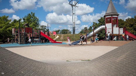
Photo
Where is located Île-Saint-Denis State Park
Île-Saint-Denis State Park — local attraction, which is located at Quai de la Marine, 93450 L'Île-Saint-Denis, France and belongs to the category — city park. Average visitor rating for this place — 4.4 (according to 586 ratings, information from open sources and relevant for 2022).
Exact location — Île-Saint-Denis State Park, marked on the map with a red marker.
You can get directions to Île-Saint-Denis State Park on the map from your location.
What else is interesting in Gennevilliers? You can see all the sights if you go to the city page.
Coordinates
Île-Saint-Denis State Park, France coordinates in decimal format: latitude — 48.949415549830995, longitude — 2.31206372513246. When converted to degrees, minutes, seconds Île-Saint-Denis State Park has the following coordinates: 48°56′57.9 north latitude and 2°18′43.43 east longitude.
Nearby cities
The largest cities that are located nearby:
- Boulogne-Billancourt — 10 km
- Rouen — 103 km
- Amiens — 107 km
- Orléans — 117 km
- Reims — 131 km
- Le Havre — 169 km
- Le Mans — 185 km
- Caen — 195 km
- Lille — 196 km
- Tours — 208 km
- Charleroi
 (Belgium) — 223 km
 - Eastbourne
 (United Kingdom) — 247 km
 - Namur (Belgium) — 249 km
- Brussels (Belgium) — 257 km
- Angers — 267 km
- Dijon — 272 km
- Metz — 282 km
- Nancy — 285 km
- Antwerp (Belgium) — 293 km
Distance to the capital
Distance to the capital (Paris) is about — 11 km.