
 Maureville
Samoëns
Gréning
Toulouse
Volx
Goudet
Méhoncourt
Saint-Hymer
Pontcarré
Maureville
Samoëns
Gréning
Toulouse
Volx
Goudet
Méhoncourt
Saint-Hymer
Pontcarré
Parc Roger Salengro on the map, Gennevilliers, France
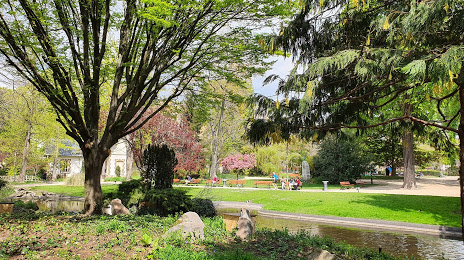
Photo
Where is located Parc Roger Salengro
Parc Roger Salengro — local attraction, which is located at 78 Bd du Général Leclerc, 92110 Clichy, France and belongs to the category — park. Average visitor rating for this place — 4.3 (according to 1471 rating, information from open sources and relevant for 2022).
Exact location — Parc Roger Salengro, marked on the map with a red marker.
You can get directions to Parc Roger Salengro on the map from your location.
What else is interesting in Gennevilliers? You can see all the sights if you go to the city page.
Coordinates
Parc Roger Salengro, France coordinates in decimal format: latitude — 48.904808618341804, longitude — 2.311994425130845. When converted to degrees, minutes, seconds Parc Roger Salengro has the following coordinates: 48°54′17.31 north latitude and 2°18′43.18 east longitude.
Nearby cities
The largest cities that are located nearby:
- Boulogne-Billancourt — 10 km
- Rouen — 103 km
- Amiens — 107 km
- Orléans — 117 km
- Reims — 131 km
- Le Havre — 169 km
- Le Mans — 185 km
- Caen — 195 km
- Lille — 196 km
- Tours — 208 km
- Charleroi
 (Belgium) — 223 km
 - Eastbourne
 (United Kingdom) — 247 km
 - Namur (Belgium) — 249 km
- Brussels (Belgium) — 257 km
- Angers — 267 km
- Dijon — 272 km
- Metz — 282 km
- Nancy — 285 km
- Antwerp (Belgium) — 293 km
Distance to the capital
Distance to the capital (Paris) is about — 6 km.