
 Maureville
Samoëns
Gréning
Toulouse
Volx
Goudet
Méhoncourt
Saint-Hymer
Pontcarré
Maureville
Samoëns
Gréning
Toulouse
Volx
Goudet
Méhoncourt
Saint-Hymer
Pontcarré
Chateau De Plaisir on the map, Plaisir, France
Photo
Where is located Chateau De Plaisir
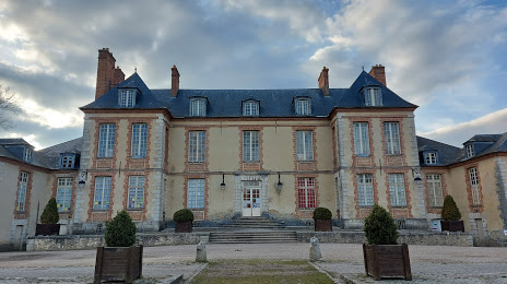
Chateau De Plaisir — local attraction, which is located at 282 Rue de la Bretechelle, 78370 Plaisir, France and belongs to the category — castle. Average visitor rating for this place — 4.3 (according to 548 ratings, information from open sources and relevant for 2022).
Exact location — Chateau De Plaisir, marked on the map with a red marker.
You can get directions to Chateau De Plaisir on the map from your location.
What else is interesting in Plaisir? You can see all the sights if you go to the city page.
Coordinates
Chateau De Plaisir, France coordinates in decimal format: latitude — 48.815530555382225, longitude — 1.9537723751277185. When converted to degrees, minutes, seconds Chateau De Plaisir has the following coordinates: 48°48′55.91 north latitude and 1°57′13.58 east longitude.
Nearby cities
The largest cities that are located nearby:
- Boulogne-Billancourt — 21 km
- Rouen — 92 km
- Orléans — 101 km
- Amiens — 122 km
- Le Havre — 152 km
- Le Mans — 157 km
- Reims — 158 km
- Caen — 172 km
- Tours — 184 km
- Lille — 215 km
- Angers — 239 km
- Eastbourne
 (United Kingdom) — 245 km
 - Charleroi
 (Belgium) — 249 km
 - Namur (Belgium) — 275 km
- Rennes — 279 km
- Brussels (Belgium) — 280 km
- Dijon — 285 km
- Crawley (United Kingdom) — 294 km
- Gillingham (United Kingdom) — 300 km
Distance to the capital
Distance to the capital (Paris) is about — 30 km.