
 Maureville
Samoëns
Gréning
Toulouse
Volx
Goudet
Méhoncourt
Saint-Hymer
Pontcarré
Maureville
Samoëns
Gréning
Toulouse
Volx
Goudet
Méhoncourt
Saint-Hymer
Pontcarré
Mont Saint-Eynard on the map, Meylan, France
Photo
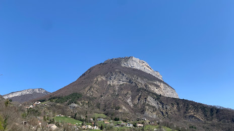
Where is located Mont Saint-Eynard
Mont Saint-Eynard — local attraction, which is located at 1,379 m and belongs to the category — -. Average visitor rating for this place — - (according to 0 ratings, information from open sources and relevant for 2022).
Exact location — Mont Saint-Eynard, marked on the map with a red marker.
You can get directions to Mont Saint-Eynard on the map from your location.
What else is interesting in Meylan? You can see all the sights if you go to the city page.
Coordinates
Mont Saint-Eynard, France coordinates in decimal format: latitude — 45.221554039146596, longitude — 5.7788621964244715. When converted to degrees, minutes, seconds Mont Saint-Eynard has the following coordinates: 45°13′17.59 north latitude and 5°46′43.9 east longitude.
Nearby cities
The largest cities that are located nearby:
- Grenoble — 5 km
- Villeurbanne — 92 km
- Lyon — 95 km
- Saint-Étienne — 111 km
- Geneva
 (Switzerland) — 113 km
 - Turin
 (Italy) — 150 km
 - Lausanne (Switzerland) — 159 km
- Aix-en-Provence — 188 km
- Nimes — 189 km
- Nice — 204 km
- Marseille — 214 km
- Clermont-Ferrand — 217 km
- Novara (Italy) — 222 km
- Besançon — 225 km
- Bern (Switzerland) — 230 km
- Toulon — 231 km
- Montpellier — 233 km
- Dijon — 240 km
- Genoa (Italy) — 266 km
Distance to the capital
Distance to the capital (Paris) is about — 480 km.