
 Maureville
Samoëns
Gréning
Toulouse
Volx
Goudet
Méhoncourt
Saint-Hymer
Pontcarré
Maureville
Samoëns
Gréning
Toulouse
Volx
Goudet
Méhoncourt
Saint-Hymer
Pontcarré
Étang des Deux Amants on the map, Val-de-Reuil, France
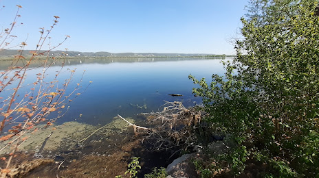
Photo
Where is located Étang des Deux Amants
Étang des Deux Amants — local attraction, which is located at no data and belongs to the category — -. Average visitor rating for this place — 4.3 (according to 100 ratings, information from open sources and relevant for 2022).
Exact location — Étang des Deux Amants, marked on the map with a red marker.
You can get directions to Étang des Deux Amants on the map from your location.
What else is interesting in Val-de-Reuil? You can see all the sights if you go to the city page.
Coordinates
Étang des Deux Amants, France coordinates in decimal format: latitude — 49.296236806443034, longitude — 1.2257140031107687. When converted to degrees, minutes, seconds Étang des Deux Amants has the following coordinates: 49°17′46.45 north latitude and 1°13′32.57 east longitude.
Nearby cities
The largest cities that are located nearby:
- Rouen — 21 km
- Le Havre — 83 km
- Boulogne-Billancourt — 88 km
- Amiens — 103 km
- Caen — 115 km
- Le Mans — 159 km
- Orléans — 160 km
- Eastbourne
 (United Kingdom) — 178 km
 - Lille — 198 km
- Reims — 203 km
- Tours — 211 km
- Crawley (United Kingdom) — 225 km
- Portsmouth (United Kingdom) — 235 km
- Gillingham (United Kingdom) — 238 km
- Angers — 239 km
- Rennes — 249 km
- Sutton (United Kingdom) — 251 km
- Southend-on-Sea (United Kingdom) — 254 km
- Southampton (United Kingdom) — 257 km
Distance to the capital
Distance to the capital (Paris) is about — 96 km.