
 Maureville
Samoëns
Gréning
Toulouse
Volx
Goudet
Méhoncourt
Saint-Hymer
Pontcarré
Maureville
Samoëns
Gréning
Toulouse
Volx
Goudet
Méhoncourt
Saint-Hymer
Pontcarré
Place Nationale on the map, Montauban, France
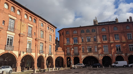
Photo
Where is located Place Nationale
Place Nationale — local attraction, which is located at 11 Pl. nationale, 82000 Montauban, France and belongs to the category — tourist attraction. Average visitor rating for this place — 4.4 (according to 2642 ratings, information from open sources and relevant for 2022).
Exact location — Place Nationale, marked on the map with a red marker.
You can get directions to Place Nationale on the map from your location.
What else is interesting in Montauban? You can see all the sights if you go to the city page.
Coordinates
Place Nationale, France coordinates in decimal format: latitude — 44.017495302110355, longitude — 1.3538989249644504. When converted to degrees, minutes, seconds Place Nationale has the following coordinates: 44°1′2.98 north latitude and 1°21′14.04 east longitude.
Nearby cities
The largest cities that are located nearby:
- Toulouse — 47 km
- Bordeaux — 176 km
- Perpignan — 193 km
- Limoges — 200 km
- Montpellier — 207 km
- Clermont-Ferrand — 236 km
- Nimes — 241 km
- Lleida
 (Spain) — 273 km
 - Terrassa (Spain) — 277 km
- Pamplona (Spain) — 278 km
- San Sebastián (Spain) — 279 km
- Sabadell (Spain) — 281 km
- Saint-Étienne — 283 km
- Mataró (Spain) — 289 km
- Santa Coloma de Gramenet (Spain) — 294 km
- Badalona (Spain) — 294 km
- L'Hospitalet de Llobregat (Spain) — 300 km
- Tarragona (Spain) — 321 km
- Zaragoza (Spain) — 321 km
Distance to the capital
Distance to the capital (Paris) is about — 544 km.