
 Maureville
Samoëns
Gréning
Toulouse
Volx
Goudet
Méhoncourt
Saint-Hymer
Pontcarré
Maureville
Samoëns
Gréning
Toulouse
Volx
Goudet
Méhoncourt
Saint-Hymer
Pontcarré
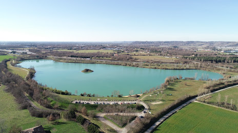
Lac Balat-David on the map, Montauban, France
Photo
Where is located Lac Balat-David
Lac Balat-David — local attraction, which is located at no data and belongs to the category — -. Average visitor rating for this place — 4.1 (according to 76 ratings, information from open sources and relevant for 2022).
Exact location — Lac Balat-David, marked on the map with a red marker.
You can get directions to Lac Balat-David on the map from your location.
What else is interesting in Montauban? You can see all the sights if you go to the city page.
Coordinates
Lac Balat-David, France coordinates in decimal format: latitude — 44.0553483617334, longitude — 1.4190917460663233. When converted to degrees, minutes, seconds Lac Balat-David has the following coordinates: 44°3′19.25 north latitude and 1°25′8.73 east longitude.
Nearby cities
The largest cities that are located nearby:
- Toulouse — 47 km
- Bordeaux — 176 km
- Perpignan — 193 km
- Limoges — 200 km
- Montpellier — 207 km
- Clermont-Ferrand — 236 km
- Nimes — 241 km
- Lleida
 (Spain) — 273 km
 - Terrassa (Spain) — 277 km
- Pamplona (Spain) — 278 km
- San Sebastián (Spain) — 279 km
- Sabadell (Spain) — 281 km
- Saint-Étienne — 283 km
- Mataró (Spain) — 289 km
- Santa Coloma de Gramenet (Spain) — 294 km
- Badalona (Spain) — 294 km
- L'Hospitalet de Llobregat (Spain) — 300 km
- Tarragona (Spain) — 321 km
- Zaragoza (Spain) — 321 km
Distance to the capital
Distance to the capital (Paris) is about — 539 km.