
 Maureville
Samoëns
Gréning
Toulouse
Volx
Goudet
Méhoncourt
Saint-Hymer
Pontcarré
Maureville
Samoëns
Gréning
Toulouse
Volx
Goudet
Méhoncourt
Saint-Hymer
Pontcarré
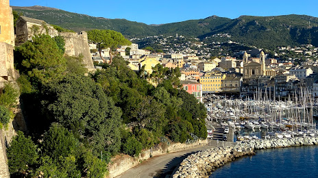
Romieu Garden (Giardinu Romieu) on the map, Bastia, France
Photo
Where is located Romieu Garden (Giardinu Romieu)
Romieu Garden (Giardinu Romieu) — local attraction, which is located at Esc. Romieu, 20200 Bastia, France and belongs to the category — garden. Average visitor rating for this place — 4.2 (according to 91 rating, information from open sources and relevant for 2022).
Exact location — Romieu Garden (Giardinu Romieu), marked on the map with a red marker.
You can get directions to Romieu Garden (Giardinu Romieu) on the map from your location.
What else is interesting in Bastia? You can see all the sights if you go to the city page.
Coordinates
Romieu Garden (Giardinu Romieu), France coordinates in decimal format: latitude — 42.694067551521535, longitude — 9.451302624921775. When converted to degrees, minutes, seconds Romieu Garden (Giardinu Romieu) has the following coordinates: 42°41′38.64 north latitude and 9°27′4.69 east longitude.
Nearby cities
The largest cities that are located nearby:
- Livorno
 (Italy) — 117 km
 - Prato (Italy) — 185 km
- Florence (Italy) — 187 km
- Genoa (Italy) — 193 km
- Nice — 208 km
- Sassari (Italy) — 231 km
- Perugia (Italy) — 242 km
- Parma (Italy) — 243 km
- Modena (Italy) — 245 km
- Bologna (Italy) — 249 km
- Terni (Italy) — 260 km
- Rome (Italy) — 266 km
- Forli (Italy) — 266 km
- Toulon — 288 km
- Ravenna (Italy) — 289 km
- Rimini (Italy) — 290 km
- Ferrara (Italy) — 291 km
- Turin (Italy) — 296 km
- Milan (Italy) — 307 km
Distance to the capital
Distance to the capital (Paris) is about — 878 km.