
 Maureville
Samoëns
Gréning
Toulouse
Volx
Goudet
Méhoncourt
Saint-Hymer
Pontcarré
Maureville
Samoëns
Gréning
Toulouse
Volx
Goudet
Méhoncourt
Saint-Hymer
Pontcarré
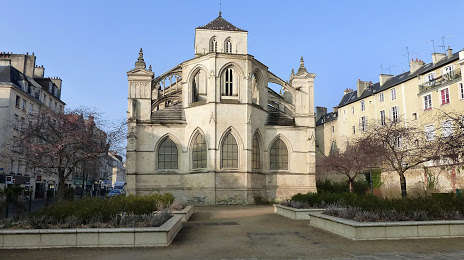
Église du Vieux Saint Sauveur on the map, Caen, France
Photo
Where is located Église du Vieux Saint Sauveur
Église du Vieux Saint Sauveur — local attraction, which is located at 13 Rue Saint-Sauveur, 14000 Caen, France and belongs to the category — church. Average visitor rating for this place — 4.4 (according to 80 ratings, information from open sources and relevant for 2022).
Exact location — Église du Vieux Saint Sauveur, marked on the map with a red marker.
You can get directions to Église du Vieux Saint Sauveur on the map from your location.
What else is interesting in Caen? You can see all the sights if you go to the city page.
Coordinates
Église du Vieux Saint Sauveur, France coordinates in decimal format: latitude — 49.18330392169121, longitude — -0.36788597476466983. When converted to degrees, minutes, seconds Église du Vieux Saint Sauveur has the following coordinates: 49°10′59.89 north latitude and -0°22′4.39 east longitude.
Nearby cities
The largest cities that are located nearby:
- Le Havre — 49 km
- Rouen — 110 km
- Le Mans — 137 km
- Rennes — 152 km
- Eastbourne
 (United Kingdom) — 181 km
 - Portsmouth (United Kingdom) — 188 km
- Angers — 189 km
- Boulogne-Billancourt — 194 km
- Bournemouth (United Kingdom) — 200 km
- Southampton (United Kingdom) — 204 km
- Amiens — 206 km
- Tours — 213 km
- Crawley (United Kingdom) — 213 km
- Orléans — 220 km
- Nantes — 235 km
- Sutton (United Kingdom) — 241 km
- Gillingham (United Kingdom) — 252 km
- Reading (United Kingdom) — 255 km
- London (United Kingdom) — 258 km
Distance to the capital
Distance to the capital (Paris) is about — 202 km.