
 Maureville
Samoëns
Gréning
Toulouse
Volx
Goudet
Méhoncourt
Saint-Hymer
Pontcarré
Maureville
Samoëns
Gréning
Toulouse
Volx
Goudet
Méhoncourt
Saint-Hymer
Pontcarré
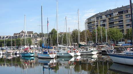
Bassin Saint-Pierre on the map, Caen, France
Photo
Where is located Bassin Saint-Pierre
Bassin Saint-Pierre — local attraction, which is located at no data and belongs to the category — -. Average visitor rating for this place — 3.6 (according to 18 ratings, information from open sources and relevant for 2022).
Exact location — Bassin Saint-Pierre, marked on the map with a red marker.
You can get directions to Bassin Saint-Pierre on the map from your location.
What else is interesting in Caen? You can see all the sights if you go to the city page.
Coordinates
Bassin Saint-Pierre, France coordinates in decimal format: latitude — 49.181957850326505, longitude — -0.3523142530438457. When converted to degrees, minutes, seconds Bassin Saint-Pierre has the following coordinates: 49°10′55.05 north latitude and -0°21′8.33 east longitude.
Nearby cities
The largest cities that are located nearby:
- Le Havre — 49 km
- Rouen — 110 km
- Le Mans — 137 km
- Rennes — 152 km
- Eastbourne
 (United Kingdom) — 181 km
 - Portsmouth (United Kingdom) — 188 km
- Angers — 189 km
- Boulogne-Billancourt — 194 km
- Bournemouth (United Kingdom) — 200 km
- Southampton (United Kingdom) — 204 km
- Amiens — 206 km
- Tours — 213 km
- Crawley (United Kingdom) — 213 km
- Orléans — 220 km
- Nantes — 235 km
- Sutton (United Kingdom) — 241 km
- Gillingham (United Kingdom) — 252 km
- Reading (United Kingdom) — 255 km
- London (United Kingdom) — 258 km
Distance to the capital
Distance to the capital (Paris) is about — 201 km.