
 Maureville
Samoëns
Gréning
Toulouse
Volx
Goudet
Méhoncourt
Saint-Hymer
Pontcarré
Maureville
Samoëns
Gréning
Toulouse
Volx
Goudet
Méhoncourt
Saint-Hymer
Pontcarré
Plage des Bonnettes on the map, Toulon, France
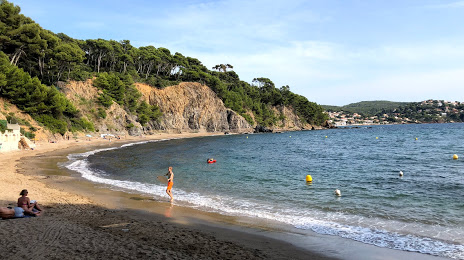
Photo
Where is located Plage des Bonnettes
Plage des Bonnettes — local attraction, which is located at no data and belongs to the category — -. Average visitor rating for this place — 4.2 (according to 93 ratings, information from open sources and relevant for 2022).
Exact location — Plage des Bonnettes, marked on the map with a red marker.
You can get directions to Plage des Bonnettes on the map from your location.
What else is interesting in Toulon? You can see all the sights if you go to the city page.
Coordinates
Plage des Bonnettes, France coordinates in decimal format: latitude — 43.098125926014866, longitude — 6.018271575029251. When converted to degrees, minutes, seconds Plage des Bonnettes has the following coordinates: 43°5′53.25 north latitude and 6°1′5.78 east longitude.
Nearby cities
The largest cities that are located nearby:
- Marseille — 49 km
- Aix-en-Provence — 59 km
- Nice — 125 km
- Nimes — 148 km
- Montpellier — 173 km
- Grenoble — 229 km
- Perpignan — 251 km
- Turin
 (Italy) — 255 km
 - Genoa (Italy) — 277 km
- Saint-Étienne — 283 km
- Villeurbanne — 303 km
- Lyon — 304 km
- Novara (Italy) — 331 km
- Mataró
 (Spain) — 337 km
 - Geneva
 (Switzerland) — 340 km
 - Sassari (Italy) — 345 km
- Livorno (Italy) — 354 km
- Badalona (Spain) — 357 km
- Santa Coloma de Gramenet (Spain) — 360 km
Distance to the capital
Distance to the capital (Paris) is about — 700 km.