
 Maureville
Samoëns
Gréning
Toulouse
Volx
Goudet
Méhoncourt
Saint-Hymer
Pontcarré
Maureville
Samoëns
Gréning
Toulouse
Volx
Goudet
Méhoncourt
Saint-Hymer
Pontcarré
Parc de la Planchette on the map, Levallois-Perret, France
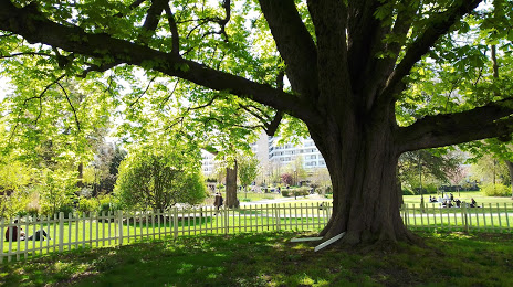
Photo
Where is located Parc de la Planchette
Parc de la Planchette — local attraction, which is located at 105 Rue du Président Wilson, 92300 Levallois-Perret, France and belongs to the category — city park. Average visitor rating for this place — 4.5 (according to 1856 ratings, information from open sources and relevant for 2022).
Exact location — Parc de la Planchette, marked on the map with a red marker.
You can get directions to Parc de la Planchette on the map from your location.
What else is interesting in Levallois-Perret? You can see all the sights if you go to the city page.
Coordinates
Parc de la Planchette, France coordinates in decimal format: latitude — 48.895151838302716, longitude — 2.2862028252251188. When converted to degrees, minutes, seconds Parc de la Planchette has the following coordinates: 48°53′42.55 north latitude and 2°17′10.33 east longitude.
Nearby cities
The largest cities that are located nearby:
- Boulogne-Billancourt — 7 km
- Rouen — 105 km
- Amiens — 111 km
- Orléans — 113 km
- Reims — 132 km
- Le Havre — 170 km
- Le Mans — 183 km
- Caen — 195 km
- Lille — 199 km
- Tours — 205 km
- Charleroi
 (Belgium) — 226 km
 - Eastbourne
 (United Kingdom) — 250 km
 - Namur (Belgium) — 252 km
- Brussels (Belgium) — 260 km
- Angers — 264 km
- Dijon — 270 km
- Metz — 282 km
- Nancy — 285 km
- Antwerp (Belgium) — 296 km
Distance to the capital
Distance to the capital (Paris) is about — 6 km.