
 Maureville
Samoëns
Gréning
Toulouse
Volx
Goudet
Méhoncourt
Saint-Hymer
Pontcarré
Maureville
Samoëns
Gréning
Toulouse
Volx
Goudet
Méhoncourt
Saint-Hymer
Pontcarré
Versailles-Chèvreloup Arboretum on the map, Rueil-Malmaison, France
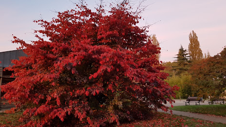
Photo
Where is located Versailles-Chèvreloup Arboretum
Versailles-Chèvreloup Arboretum — local attraction, which is located at 30 Rte de Versailles, 78150 Le Chesnay-Rocquencourt, France and belongs to the category — arboretum. Average visitor rating for this place — 4.1 (according to 138 ratings, information from open sources and relevant for 2022).
Exact location — Versailles-Chèvreloup Arboretum, marked on the map with a red marker.
You can get directions to Versailles-Chèvreloup Arboretum on the map from your location.
What else is interesting in Rueil-Malmaison? You can see all the sights if you go to the city page.
Coordinates
Versailles-Chèvreloup Arboretum, France coordinates in decimal format: latitude — 48.830582997319645, longitude — 2.111550325222811. When converted to degrees, minutes, seconds Versailles-Chèvreloup Arboretum has the following coordinates: 48°49′50.1 north latitude and 2°6′41.58 east longitude.
Nearby cities
The largest cities that are located nearby:
- Boulogne-Billancourt — 7 km
- Rouen — 99 km
- Orléans — 110 km
- Amiens — 112 km
- Reims — 140 km
- Le Havre — 163 km
- Le Mans — 175 km
- Caen — 187 km
- Tours — 199 km
- Lille — 203 km
- Charleroi
 (Belgium) — 233 km
 - Eastbourne
 (United Kingdom) — 247 km
 - Angers — 257 km
- Namur (Belgium) — 258 km
- Brussels (Belgium) — 265 km
- Dijon — 275 km
- Metz — 291 km
- Nancy — 293 km
- Crawley (United Kingdom) — 296 km
Distance to the capital
Distance to the capital (Paris) is about — 18 km.