
 Maureville
Samoëns
Gréning
Toulouse
Volx
Goudet
Méhoncourt
Saint-Hymer
Pontcarré
Maureville
Samoëns
Gréning
Toulouse
Volx
Goudet
Méhoncourt
Saint-Hymer
Pontcarré
Champs-Élysées on the map, Orsay, France
Photo
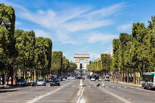
Where is located Champs-Élysées
Champs-Élysées — local attraction, which is located at 1.91 km and belongs to the category — -. Average visitor rating for this place — - (according to 0 ratings, information from open sources and relevant for 2022).
Exact location — Champs-Élysées, marked on the map with a red marker.
You can get directions to Champs-Élysées on the map from your location.
What else is interesting in Orsay? You can see all the sights if you go to the city page.
Coordinates
Champs-Élysées, France coordinates in decimal format: latitude — 48.85992961594145, longitude — 2.326497025223864. When converted to degrees, minutes, seconds Champs-Élysées has the following coordinates: 48°51′35.75 north latitude and 2°19′35.39 east longitude.
Nearby cities
The largest cities that are located nearby:
- Boulogne-Billancourt — 16 km
- Orléans — 90 km
- Rouen — 114 km
- Amiens — 133 km
- Reims — 147 km
- Le Mans — 166 km
- Le Havre — 174 km
- Tours — 183 km
- Caen — 193 km
- Lille — 222 km
- Angers — 246 km
- Charleroi
 (Belgium) — 247 km
 - Dijon — 262 km
- Eastbourne
 (United Kingdom) — 265 km
 - Namur (Belgium) — 272 km
- Brussels (Belgium) — 282 km
- Nancy — 292 km
- Metz — 292 km
- Rennes — 293 km
Distance to the capital
Distance to the capital (Paris) is about — 2 km.