
 Maureville
Samoëns
Gréning
Toulouse
Volx
Goudet
Méhoncourt
Saint-Hymer
Pontcarré
Maureville
Samoëns
Gréning
Toulouse
Volx
Goudet
Méhoncourt
Saint-Hymer
Pontcarré
Église Saint-Louis de Vincennes on the map, Saint-Mandé, France
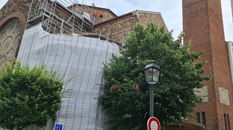
Photo
Where is located Église Saint-Louis de Vincennes
Église Saint-Louis de Vincennes — local attraction, which is located at 22 Rue Fays, 94300 Vincennes, France and belongs to the category — catholic church. Average visitor rating for this place — 4.5 (according to 96 ratings, information from open sources and relevant for 2022).
Exact location — Église Saint-Louis de Vincennes, marked on the map with a red marker.
You can get directions to Église Saint-Louis de Vincennes on the map from your location.
What else is interesting in Saint-Mandé? You can see all the sights if you go to the city page.
Coordinates
Église Saint-Louis de Vincennes, France coordinates in decimal format: latitude — 48.84811787835307, longitude — 2.4189168980405173. When converted to degrees, minutes, seconds Église Saint-Louis de Vincennes has the following coordinates: 48°50′53.22 north latitude and 2°25′8.1 east longitude.
Nearby cities
The largest cities that are located nearby:
- Boulogne-Billancourt — 13 km
- Orléans — 111 km
- Rouen — 116 km
- Amiens — 117 km
- Reims — 125 km
- Le Havre — 181 km
- Le Mans — 188 km
- Lille — 203 km
- Caen — 205 km
- Tours — 206 km
- Charleroi
 (Belgium) — 225 km
 - Namur (Belgium) — 249 km
- Dijon — 259 km
- Eastbourne
 (United Kingdom) — 260 km
 - Brussels (Belgium) — 260 km
- Angers — 269 km
- Metz — 274 km
- Nancy — 275 km
- Antwerp (Belgium) — 297 km
Distance to the capital
Distance to the capital (Paris) is about — 5 km.