
 Maureville
Samoëns
Gréning
Toulouse
Volx
Goudet
Méhoncourt
Saint-Hymer
Pontcarré
Maureville
Samoëns
Gréning
Toulouse
Volx
Goudet
Méhoncourt
Saint-Hymer
Pontcarré
Grand Parc des Docks de Saint-Ouen on the map, Saint-Ouen, France
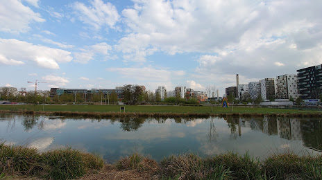
Photo
Where is located Grand Parc des Docks de Saint-Ouen
Grand Parc des Docks de Saint-Ouen — local attraction, which is located at 12 Rue Albert Dhalenne, 93400 Saint-Ouen, France and belongs to the category — park. Average visitor rating for this place — 4.2 (according to 1396 ratings, information from open sources and relevant for 2022).
Exact location — Grand Parc des Docks de Saint-Ouen, marked on the map with a red marker.
You can get directions to Grand Parc des Docks de Saint-Ouen on the map from your location.
What else is interesting in Saint-Ouen? You can see all the sights if you go to the city page.
Coordinates
Grand Parc des Docks de Saint-Ouen, France coordinates in decimal format: latitude — 48.91556202593096, longitude — 2.3271168980429113. When converted to degrees, minutes, seconds Grand Parc des Docks de Saint-Ouen has the following coordinates: 48°54′56.02 north latitude and 2°19′37.62 east longitude.
Nearby cities
The largest cities that are located nearby:
- Boulogne-Billancourt — 11 km
- Rouen — 106 km
- Amiens — 109 km
- Orléans — 116 km
- Reims — 128 km
- Le Havre — 172 km
- Le Mans — 187 km
- Lille — 197 km
- Caen — 198 km
- Tours — 208 km
- Charleroi
 (Belgium) — 223 km
 - Namur (Belgium) — 248 km
- Eastbourne
 (United Kingdom) — 250 km
 - Brussels (Belgium) — 256 km
- Angers — 268 km
- Dijon — 268 km
- Metz — 279 km
- Nancy — 282 km
- Antwerp (Belgium) — 293 km
Distance to the capital
Distance to the capital (Paris) is about — 7 km.