
 Maureville
Samoëns
Gréning
Toulouse
Volx
Goudet
Méhoncourt
Saint-Hymer
Pontcarré
Maureville
Samoëns
Gréning
Toulouse
Volx
Goudet
Méhoncourt
Saint-Hymer
Pontcarré
Bains Douches Municipaux on the map, Laval, France
Photo
Where is located Bains Douches Municipaux
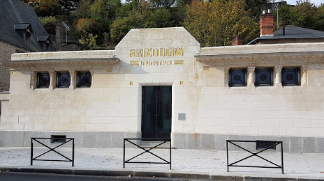
Bains Douches Municipaux — local attraction, which is located at 32 Quai Albert Goupil, 53000 Laval, France and belongs to the category — historical landmark. Average visitor rating for this place — 4.2 (according to 38 ratings, information from open sources and relevant for 2022).
Exact location — Bains Douches Municipaux, marked on the map with a red marker.
You can get directions to Bains Douches Municipaux on the map from your location.
What else is interesting in Laval? You can see all the sights if you go to the city page.
Coordinates
Bains Douches Municipaux, France coordinates in decimal format: latitude — 48.066994030905974, longitude — -0.7691478019869585. When converted to degrees, minutes, seconds Bains Douches Municipaux has the following coordinates: 48°4′1.18 north latitude and -0°46′8.93 east longitude.
Nearby cities
The largest cities that are located nearby:
- Rennes — 67 km
- Angers — 68 km
- Le Mans — 72 km
- Nantes — 112 km
- Caen — 125 km
- Tours — 132 km
- Le Havre — 169 km
- Orléans — 199 km
- Rouen — 202 km
- Boulogne-Billancourt — 234 km
- Brest — 275 km
- Limoges — 293 km
- Amiens — 296 km
- Bournemouth
 (United Kingdom) — 302 km
 - Portsmouth (United Kingdom) — 304 km
- Eastbourne (United Kingdom) — 306 km
- Southampton (United Kingdom) — 316 km
- Crawley (United Kingdom) — 337 km
- Exeter (United Kingdom) — 350 km
Distance to the capital
Distance to the capital (Paris) is about — 246 km.