
 Maureville
Samoëns
Gréning
Toulouse
Volx
Goudet
Méhoncourt
Saint-Hymer
Pontcarré
Maureville
Samoëns
Gréning
Toulouse
Volx
Goudet
Méhoncourt
Saint-Hymer
Pontcarré
Château de Vaugien on the map, Gif-sur-Yvette, France
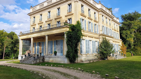
Photo
Where is located Château de Vaugien
Château de Vaugien — local attraction, which is located at 1 Dom. de Vaugien, 78470 Saint-Rémy-lès-Chevreuse, France and belongs to the category — castle. Average visitor rating for this place — 4.4 (according to 67 ratings, information from open sources and relevant for 2022).
Exact location — Château de Vaugien, marked on the map with a red marker.
You can get directions to Château de Vaugien on the map from your location.
What else is interesting in Gif-sur-Yvette? You can see all the sights if you go to the city page.
Coordinates
Château de Vaugien, France coordinates in decimal format: latitude — 48.70219697558254, longitude — 2.0876648980353667. When converted to degrees, minutes, seconds Château de Vaugien has the following coordinates: 48°42′7.91 north latitude and 2°5′15.59 east longitude.
Nearby cities
The largest cities that are located nearby:
- Boulogne-Billancourt — 17 km
- Orléans — 90 km
- Rouen — 111 km
- Amiens — 132 km
- Reims — 150 km
- Le Mans — 162 km
- Le Havre — 170 km
- Tours — 181 km
- Caen — 189 km
- Lille — 223 km
- Angers — 243 km
- Charleroi
 (Belgium) — 249 km
 - Eastbourne
 (United Kingdom) — 262 km
 - Dijon — 266 km
- Namur (Belgium) — 274 km
- Brussels (Belgium) — 284 km
- Rennes — 289 km
- Nancy — 296 km
- Metz — 296 km
Distance to the capital
Distance to the capital (Paris) is about — 26 km.