
 Maureville
Samoëns
Gréning
Toulouse
Volx
Goudet
Méhoncourt
Saint-Hymer
Pontcarré
Maureville
Samoëns
Gréning
Toulouse
Volx
Goudet
Méhoncourt
Saint-Hymer
Pontcarré
Château de L'Etang on the map, Pantin, France
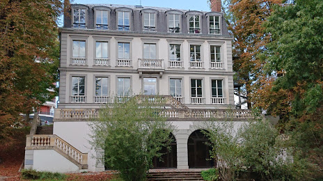
Photo
Where is located Château de L'Etang
Château de L'Etang — local attraction, which is located at 17 Rue François Mitterrand, 93170 Bagnolet, France and belongs to the category — historical landmark. Average visitor rating for this place — 4.1 (according to 104 ratings, information from open sources and relevant for 2022).
Exact location — Château de L'Etang, marked on the map with a red marker.
You can get directions to Château de L'Etang on the map from your location.
What else is interesting in Pantin? You can see all the sights if you go to the city page.
Coordinates
Château de L'Etang, France coordinates in decimal format: latitude — 48.875741897834345, longitude — 2.423309798041488. When converted to degrees, minutes, seconds Château de L'Etang has the following coordinates: 48°52′32.67 north latitude and 2°25′23.92 east longitude.
Nearby cities
The largest cities that are located nearby:
- Boulogne-Billancourt — 14 km
- Amiens — 111 km
- Rouen — 112 km
- Orléans — 116 km
- Reims — 124 km
- Le Havre — 178 km
- Le Mans — 191 km
- Lille — 197 km
- Caen — 203 km
- Tours — 210 km
- Charleroi
 (Belgium) — 221 km
 - Namur (Belgium) — 246 km
- Eastbourne
 (United Kingdom) — 255 km
 - Brussels (Belgium) — 255 km
- Dijon — 263 km
- Angers — 272 km
- Metz — 274 km
- Nancy — 276 km
- Antwerp (Belgium) — 292 km
Distance to the capital
Distance to the capital (Paris) is about — 6 km.