
 Maureville
Samoëns
Gréning
Toulouse
Volx
Goudet
Méhoncourt
Saint-Hymer
Pontcarré
Maureville
Samoëns
Gréning
Toulouse
Volx
Goudet
Méhoncourt
Saint-Hymer
Pontcarré
Scarpe on the map, Saint-Amand-les-Eaux, France
Photo
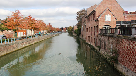
Where is located Scarpe
Scarpe — local attraction, which is located at 94 km and belongs to the category — -. Average visitor rating for this place — 4.6 (according to 19 ratings, information from open sources and relevant for 2022).
Exact location — Scarpe, marked on the map with a red marker.
You can get directions to Scarpe on the map from your location.
What else is interesting in Saint-Amand-les-Eaux? You can see all the sights if you go to the city page.
Coordinates
Scarpe, France coordinates in decimal format: latitude — 50.44091982065044, longitude — 3.4280662890499456. When converted to degrees, minutes, seconds Scarpe has the following coordinates: 50°26′27.31 north latitude and 3°25′41.04 east longitude.
Nearby cities
The largest cities that are located nearby:
- Lille — 33 km
- Charleroi
 (Belgium) — 72 km
 - Brussels (Belgium) — 78 km
- Amiens — 101 km
- Namur (Belgium) — 102 km
- Antwerp (Belgium) — 109 km
- Reims — 139 km
- Liège (Belgium) — 152 km
- Breda
 (Netherlands) — 156 km
 - Maastricht (Netherlands) — 164 km
- Tilburg (Netherlands) — 168 km
- Dordrecht (Netherlands) — 174 km
- Rotterdam (Netherlands) — 178 km
- Eindhoven (Netherlands) — 178 km
- 's-Hertogenbosch (Netherlands) — 189 km
- The Hague (Netherlands) — 189 km
- Aachen
 (Germany) — 189 km
 - Zoetermeer (Netherlands) — 192 km
- Boulogne-Billancourt — 198 km
Distance to the capital
Distance to the capital (Paris) is about — 192 km.