
 Maureville
Samoëns
Gréning
Toulouse
Volx
Goudet
Méhoncourt
Saint-Hymer
Pontcarré
Maureville
Samoëns
Gréning
Toulouse
Volx
Goudet
Méhoncourt
Saint-Hymer
Pontcarré
Saint-Nicaise de Reims on the map, Reims, France
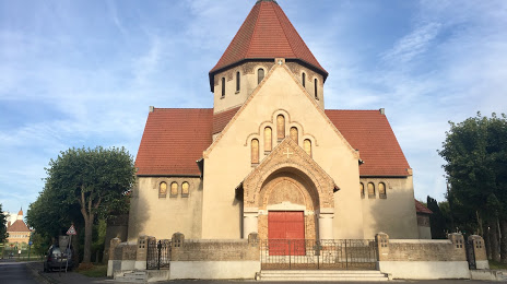
Photo
Where is located Saint-Nicaise de Reims
Saint-Nicaise de Reims — local attraction, which is located at 2 Pl. du 11 Novembre, 51100 Reims, France and belongs to the category — catholic church. Average visitor rating for this place — 4.5 (according to 85 ratings, information from open sources and relevant for 2022).
Exact location — Saint-Nicaise de Reims, marked on the map with a red marker.
You can get directions to Saint-Nicaise de Reims on the map from your location.
What else is interesting in Reims? You can see all the sights if you go to the city page.
Coordinates
Saint-Nicaise de Reims, France coordinates in decimal format: latitude — 49.248006261164804, longitude — 4.055029698054732. When converted to degrees, minutes, seconds Saint-Nicaise de Reims has the following coordinates: 49°14′52.82 north latitude and 4°3′18.11 east longitude.
Nearby cities
The largest cities that are located nearby:
- Charleroi
 (Belgium) — 131 km
 - Boulogne-Billancourt — 138 km
- Amiens — 142 km
- Namur (Belgium) — 146 km
- Metz — 156 km
- Lille — 166 km
- Nancy — 169 km
- Brussels (Belgium) — 177 km
- Liège (Belgium) — 187 km
- Trier
 (Germany) — 194 km
 - Maastricht
 (Netherlands) — 211 km
 - Rouen — 212 km
- Saarbrücken (Germany) — 214 km
- Orléans — 217 km
- Antwerp (Belgium) — 218 km
- Aachen (Germany) — 221 km
- Dijon — 227 km
- Eindhoven (Netherlands) — 261 km
- Breda (Netherlands) — 262 km
Distance to the capital
Distance to the capital (Paris) is about — 132 km.