
 Maureville
Samoëns
Gréning
Toulouse
Volx
Goudet
Méhoncourt
Saint-Hymer
Pontcarré
Maureville
Samoëns
Gréning
Toulouse
Volx
Goudet
Méhoncourt
Saint-Hymer
Pontcarré
Musée de l'Aéronautique locale on the map, Reims, France
Photo
Where is located Musée de l'Aéronautique locale
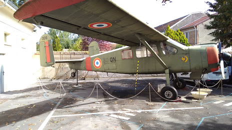
Musée de l'Aéronautique locale — local attraction, which is located at Pl. de la Mairie, 51450 Bétheny, France and belongs to the category — museum. Average visitor rating for this place — 4.1 (according to 27 ratings, information from open sources and relevant for 2022).
Exact location — Musée de l'Aéronautique locale, marked on the map with a red marker.
You can get directions to Musée de l'Aéronautique locale on the map from your location.
What else is interesting in Reims? You can see all the sights if you go to the city page.
Coordinates
Musée de l'Aéronautique locale, France coordinates in decimal format: latitude — 49.28593408807736, longitude — 4.058480098056079. When converted to degrees, minutes, seconds Musée de l'Aéronautique locale has the following coordinates: 49°17′9.36 north latitude and 4°3′30.53 east longitude.
Nearby cities
The largest cities that are located nearby:
- Charleroi
 (Belgium) — 131 km
 - Boulogne-Billancourt — 138 km
- Amiens — 142 km
- Namur (Belgium) — 146 km
- Metz — 156 km
- Lille — 166 km
- Nancy — 169 km
- Brussels (Belgium) — 177 km
- Liège (Belgium) — 187 km
- Trier
 (Germany) — 194 km
 - Maastricht
 (Netherlands) — 211 km
 - Rouen — 212 km
- Saarbrücken (Germany) — 214 km
- Orléans — 217 km
- Antwerp (Belgium) — 218 km
- Aachen (Germany) — 221 km
- Dijon — 227 km
- Eindhoven (Netherlands) — 261 km
- Breda (Netherlands) — 262 km
Distance to the capital
Distance to the capital (Paris) is about — 133 km.